
- Popular Post


Frank Trough
-
Posts
821 -
Joined
-
Last visited
Content Type
Forums
Blogs
Gallery
Events
Learn About Weather and Meteorology
Community guides
Posts posted by Frank Trough
-
-
Lots of chopping and changing but the general direction of travel all seems to be heading in the wrong direction in the mid term. Ukmo proves the dream crusher again.
Was it nick Sussex that used to say something like "if the ukmo says no you won't get snow"?
Something like that.
-
 4
4
-
-
19 minutes ago, Man With Beard said:
They haven't all followed the UKMO...

...but on the whole Steve Murr clearly made a better call than I did a couple of hours ago.
Have we really seen the final solution on this, though?
No, but "direction of travel" i think is important.
-
1 minute ago, Ali1977 said:
I didn't see the LRF but if they are punting for a NEly next weekend then their own "better" models may not be following the 12zs and ECM evening run - or filmed prior to these anyway. Shame we don't get the info anymore from IanF.
I honestly think they might be playing catch up. I can still see a dry, frosty spell developing which won't be anything other than quite enjoyable. It's been quite seasonal even here the last few days. I guess we might end up with a NE surface feed?
At some point we are going to pay for this dry weather...wet westerly february? The westerlies will return.
-
3
-
-
13 minutes ago, JOPRO said:
Can anyone explain why the UKMO is pants when it is out on its own showing a cold synopsis, but is the slayer of cold spells when it is on its own showing mild synopsis in the 96-120hr range. A genuine question not a toy throw ,would be interested to hear some on the more seasoned posters thoughts on this?
Because extremes of hot in summer and cold winter seem to find it impossible to verify. Any model showing a more moderate solution has a higher chance of being correct.
-
2 minutes ago, radiohead said:
We should prepare for an inevitable downgrade on the 12Z because I don't think much of an upgrade is possible following that...
Let's see where it stands with the GEFS.
I'm going to stick my neck out and say it will be "on the colder side" of the ensembles...
-
3
-
-
7 minutes ago, ajpoolshark said:
posting ppn charts at T96 and analysing then with a fine toothcombe...........that old chestnut.....lol
snow is hard enough to forecast at T24 let alone T96+!......see john holmes's fine post in the learner's area for snow forecasting and not get hung up on these ppn charts
It's pretty easy to forecast snow for southern coastal counties in these scenarios: There won't be any, it will be rain.
Still worth keeping an eye on over the next few days for more inland areas. Cold and frosty will do me for now and we wait and see if the second phase will deliver anything more significantly wintry.
-
6
-
-
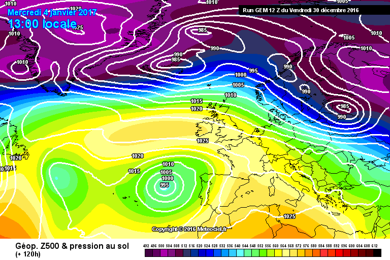
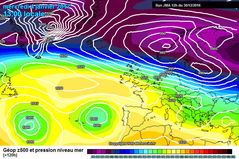
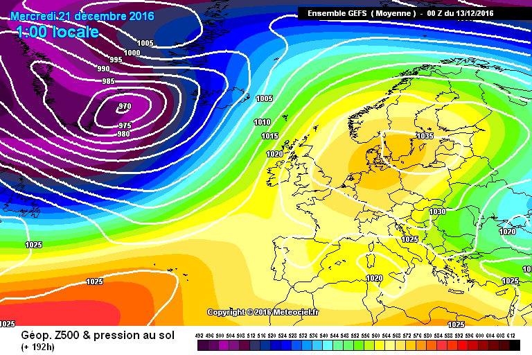
29 minutes ago, Man With Beard said:
ECM mean vs GEFS mean at T192. Big differences for the UK, potentially
that looks to me like a brilliant example of "tiny Island in the north Atlantic" syndrome. Globally speaking there really are pretty miniscule differences in those two charts but for us on the ground?!
-
3
-
-
19 minutes ago, I remember Atlantic 252 said:
GFS and ECM still different, I'm in team GFS, but you have to feel ECM has this right, especially as experts say ECM better than GFS
GFS cold dry, ECM normal Dec weather
I think there are plenty in here (most?) who are hoping the GFS has got this sorted. It would be nice and seasonal which would make a change. However, you have to ask yourself which is most likely given the law of sod and previous, bitter experience? The little voice in my head is chirping away like Adam Gilchrist behind the stumps telling me not to believe the GFS.
Haven't seen anything from IDO of late - he normally favours the GFS/GEFS over the ECM so it would be interesting to get his take on this. The GEFS are certainly keen on something seasonal.
-
3
-
-
06z GFS = BANK please. I don't think it's going to get better than that for run up to christmas so cool feeling with a chance of some frost as time goes on suits me fine. At least that would feel vaguely festive.
-
1
-
-
So when we sort out t+120 the "bimodality" may disappear?
-
3 minutes ago, phil nw. said:
Looking at the gefs clusters for the end of next week day 11 and they are pretty much 50/50 whether the high is far enough north to avoid the south westerly flow across the top.There a 4 clustering groups.The largest at 45% should be just about ok for surface cold but the rest are varying degrees of Atlantic influence over the top.
Would like to see them swing into a majority towards the high a tad further north to swing it towards a cold continental surface flow.
As a rank amateur (really rank),can I ask what will determine whether the high is far enough north to avoid the westerly influence? Will it be how much "propping up" there is, how much goes over the top, how the split happens at t+96? Or something else - perhaps my wife will ultimately decide? She's good at that. She's got Christmas sorted.
-
1
-
-
To be honest, just catching up with the ecm op this evening, I would gladly bank that run for now let alone summer.
I should have added that I mean in the context of what we could get....in fact, what was showing on the ops just a couple of days ago.
-
3
-
-
6 minutes ago, Mr_Pessimistic said:
Nobody knows is the correct answer. People on here fall for the same LRF nonsense every single year. Watch the Mets forecast for a MAX of 5 days ahead to get the general picture of will it likely be warm or cold, no details, and you won't dissapoint yourselves, time, and time again.
I bet Christmas is a bundle of laughs in your house!
You are obviously right though - there's no denying that! Whatever we get will eventually have to appear on an ops chart at less than t+120. However, that does take a bit of fun out of it all, doesn't it?!
-
4
-
-
13 minutes ago, bluearmy said:
As ian posted, the temps drop back after mid month as the high anomolys drift back across the east Atlantic after the several day incursion of Atlantic mobility. (Mainly affecting the nw uk). The euro high anomolys remain fairly intact although weakish as per recent output. as normal heights over Europe are high, anything other than a low or neutral anomoly return to our south is not going to bring deep cold this far. so blocking remains the story but probably never getting far enough north to allow an old fashioned easterly
Let's hope that it can still get far enough north to at least allow some frosty clear weather. The alternative surely would be just a continuation of next week's horror show?
-
Regardless of the longer range predictions which still have plenty of time to materialise, my focus now is getting any pattern other than the euro-high nonsense being shown into the reliable. Anything is better than the mid term ecm this morning. GFS isn't much more appealing either.
i suppose better to have the mild stuff now so we are still in with a shout of a change before the festive season.
-
2
-
-
41 minutes ago, bluearmy said:
I think many will take the nitrous oxide after viewing the models and not finding wintry nirvana pre mid month.
For my part, I will continue to view the removal of high anomoly over Europe at the end of GEFS as a positive.
Those high anomalies will be eroded eventually - let's hope the GEFS are on the right track and they do get eroded before we eat up too much of December. Tell me it's unlikely they are underestimating the robustness of those heights at that range?
I've loved this frosty spell - absolutely gorgeous this morning driving in through the frosty wilderness of north Hampshire.
This doesn't fill me with joy.
-
3
-
-
certainly some "relative warmth" on offer from the 06z:
fortunately it remains well outside the reliable and hopefully some changes earlier on will render this outcome unlikely.
-
4 minutes ago, Paul_1978 said:
Is he trolling?
Seriously, how can anybody be "trolled" about the weather? it's the weather! we can't control it. More pertinently, how can anybody allow themselves to be "trolled" about the weather? somebody taking a view other than "it's going to be 1962/63 all over again" is just taking a different view.
Weird, but I've seen a few instances lately where people are being accused of it which is totally daft.
-
5
-
-
42 minutes ago, Paul_1978 said:
Show me the last 240 chart that verified and you might have something.
this was the GFS 240 chart for today:
and the ECM:
I know these are not a hemispheric view but they are not a million miles away in terms of what we've actually got I don't think:
But of course no charts actually "verify" in their entirety, especially at t+240.
-
1
-
-
11 minutes ago, Geordiesnow said:
If high pressure does dominate, lets just hope its a clear high rather than a cloudy one as the cold frosty nights and sunny/foggy days are a lot more interesting than cold grey days with no frost. I think the biggest uncertainty will be the cloud cover, hopefully after a cloudier few days from Wednesday onwards we should see clearer conditions come in from the North as the Northerly flow just misses us but it should bring cooler/clearer air in and with the high forecast to be right on top of the UK hopefully we will see the sunny days and frosty nights.
absolutely agree with this. Cold, frosty at night and clear by day and feeling very seasonal - fingers crossed we dodge the cloud. To be honest I think it's a great start to winter - too often down here (in the subtropical south) genuine snow chances elsewhere translate into raw, cloudy, cold rain for us. Personally some proper frosty weather to welcome the start of the festive season and beginning of winter is actually preferable in many respects.
And as IDO earlier (and numerous others) points out, who knows where it leads after that? Surely our time has come for the high to migrate somewhere favourable for a snowy outbreak for a change?
-
5
-
-
Not too much wrong with dry and frosty next week is there? As always pointless looking beyond +144, tempting as it always is. Anything in week 2 will change.
-
7
-
-
- Popular Post
- Popular Post
1 hour ago, Nick L said:Can we keep Met Office outlook discussion in the relevant threads please? Any further posts will be removed. Keep this thread for model discussion
I don't really understand why it doesn't belong in this thread? it's just discussing the met office discussing the models? It is model discussion isn't it?
-
11
-
And in recent years the red arrow always wins. Black Friday, black arrow. It's time for a bit of luck. frosty and dry would suit me fine if that's how it has to be.
-
4
-
-
Leaving the hunt for signs of cold in the latest GBBO and Quasi Mojo alone for a second, it's still looking like quite a wild night in the south on saturday with plenty of rain and strong winds. If you have hatches, i would suggest battening them down....
This has been modelled pretty well for a good few days now (providing it verifies like this of course):
-
3
-


Model Output Discussion 29th December - Into mid-Winter.
in Forecast Model Discussion
Posted
Thing is, if the GEFS suite had been correct previously we certainly wouldn't be looking at an upcoming period of average fare.
i have zero confidence in the next predicted pattern change, we've been here twice before (at least) this winter.
Tempered expectations are a good thing I think.