


3 Counties & Ea Cold Spell Discussion Part 3
-
Recently Browsing 0 members
- No registered users viewing this page.
-
Our picks
-

Northern lights spectacular May 2024
Eagle Eye posted a post in a topic,
Amazing Aurora photos from last night.
Picked By
Paul, -
-
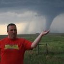
Major USA tornado outbreak possible
WeatherArc posted a post in a topic,
A major tornado outbreak is possible in Kansas and Oklahoma on Sunday 6th, May.
Picked By
Paul, -
-
How to quote a part (or all) of someone's post
Paul posted a guide in Posts and Posting,
While we trial the new 'reply-to' rather than quote button on the community, you may be wondering how to quote someone's post - click here to read a quick guide.-
- 0 replies
Picked By
Paul, -
-
Magpie Mine Aurora
weatherobsuk posted a gallery image in Non-weather related photos,
A spectacular Aurora display over Magpie Mine late evening on Friday 1st Dec 2023.-
-
- 0 replies
Picked By
Paul, -
-
-
Latest Weather News
UK Storm and Severe Convective Forecast
UK Severe Convective & Storm Forecast - Issued 2024-05-16 14:02:54 Valid: 16/05/2024 1400 - 17/05/2024 0600 THUNDERSTORM WARNING - THURS 16 MAY 2024 Click here for the full forecast

Summer 2024: Seasonal models suggest a very warm one, but rainfall signal uncertain
A look at what seasonal weather models indicate show from their May updates for summer 2024. General theme is for temperatures to be above average all 3 months, but the rainfall signal looks mixed. Nothing indicating a very dry summer. View the full blog here
Another sunny weekend but not as quite warm, with a scattering of showers
This coming weekend will bring warm sunny spells but also a scattering of showers and cooler nights. It's still a fine end to the week just not quite as stunning. Read the full update here


Recommended Posts