


snowy weather
-
Posts
398 -
Joined
-
Last visited
Content Type
Forums
Blogs
Gallery
Events
Learn About Weather and Meteorology
Community guides
Posts posted by snowy weather
-
-
On 24/07/2016 at 20:21, iapennell said:
Where I live near Nenthead, high up in the North Pennines, we used to get air frosts in August. The last time that happened was in 1999!
Certainly frost used to be more frequent (and more severe) in autumns gone by. I have recorded -3C in late September in 1995 and in October I have recorded -8C (in 1983 and 1993). However in the last 13 years I have recorded nothing below -3C in October and there have been seasons where not a single air-frost has occurred until November. That would have been unthinkable at over 400 metres up in the North Pennines at one time. We also used to have early snowfalls, there was an October evening in the mid 1970s (1974, I believe) when my parents rushed out to get the cows in on our farm (where I still live) because it was snowing hard and the poor cows had four inches of thick snow on their backs!! Yes, this was mid-October! We have now had no October snowfall for eight years. At another extreme we also used to get more severe gales- in early autumn. We would get gales in August and September and severe ones too,- on 27th September 1982 a really severe gale uprooted a tree in the little paddock nest to our home- severe gales are now rare before November.
The autumn storm tracks have shifted northwards to the Arctic and though the westerlies associated with them have become a bit stronger they miss all but NW Scotland until late in the autumn- so we don't get the autumnal equinox gales we once did. Instead these Westerlies- to the north- form a barrier preventing the penetration of very cold Arctic air over Britain for most of the autumn. Also the Arctic has also become a bit less cold in recent autumns. All of which means less early snowfalls and less early sharp frosts. I suspect that a similar theme will unfold this autumn too.
Sorry for the late reply (busy with my thesis)
Thanks for this detailed reply. Its really interesting to know. My mom says that in the 80's when she used to start school again in September, it used to be quite chilly.
Why have storm tracks shifted north?
I read an article the other day that clouds are moving north
Its amazing that over the last couple of winters, I can count of one hand the number of times I have seen the frost.
On Christmas eve at night I remember I only had a jacket on!!
Do you think we could ever see a frost again in September?
-
Is it true that in the 70's and 80's we used to have frosts in September?
-
Thank you for this excellent explanation.Upper air charts such the 500mb are contour charts are drawn up using lines of equal geopotential height known as isohypse. These represent a constant pressure surface so no matter what the value of them they always represent 500mb. Without going in to how they are calculated a rule of thumb would be the lower the geopotential height, the lower the 500mb level, the cooler the air. They can be used to identify troughs and ridges as the heights will be lower with the former and higher with the latter.
P.S
Geopotential height is the distance above the earth's surface if it was a perfect and flat sphere.
EDIT
I've slightly adjusted the P.S. so it makes slightly better sense/
An example. Don't worry about the anomaly bit. Blue indicate troughs (LP) and red/orange ridges (HP). The heights are in decametres.so X 10 for geopotential metres.
-
I’ve just been catching up with this thread; there are quite some interesting thoughts and contributions about this matter. Great to see this all being collected in this thread.
The atmospheric angular momentum – although I understand the general concept – is still too difficult to get my head around, but I think this will improve over the course of the year with some extra study and reading contributions on this site.
What piqued my interest is the relationship between the cooler-than-average sea surface temperatures in the Atlantic and lower geopotential heights there. In fact, this could even be related to the extraordinarily high temperatures on the European mainland.
Cooler than average sea surface temperatures in the Atlantic and low pressure activity
For the analysis I am going to use climate composites of last summer (2015).
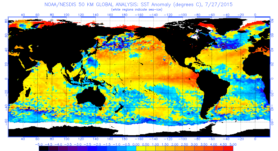
As the name of the thread suggests, the SSTS in the central Atlantic are much cooler than normal.
Sea surface temperature anomalies between June and August, 2015. Courtesy: NOAA.
As many of us have noted during past summer, a frequent occurrence during last summer was the presence of a 500 hPa trough located on average just to the northwest of Iceland. This translated to a negative anomaly in heights over that very same area:
Geopotential height anomalies between June and August, 2015. Courtesy: NOAA.
This area completely overlaps with the negative sea surface temperatures just west of Europe. Coincidence? Most likely not, but I do not yet get why cooler than normal SSTS would relate to lower than average heights. What I thought is that cooler than normal surface temperatures are related to descending motions, and as a result more high pressure activity. Any explanation would be greatly appreciated!
What does this have to do with the European heat?
An interesting question is how the aforementioned troughing (and associated low pressure activity) relates to the heat wave in central Europe. For that purpose, we look at the geopotential height anomalies once again:
Geopotential height anomalies between June and August, 2015. Courtesy: NOAA.
The answer lies in the part ahead of this troughing. Because this troughing was so persistent and deep, a continuous supply of very warm African air was pumped up northeastward on the southeastern flank of this troughing.
A final small contribution
Finally, it is also nice to look at longitude-height cross sections. This figure is tough to interpret, though.
Cross section of geopotential height anomalies between 50E and 50W, at 50 N between June and August.
What we see here is that between 40W and 20W, there is a clear negative height anomaly (lower than average pressure). This negative height anomaly is directly superimposed over the colder than average SSTS over the Atlantic.
On the other side, we see the much higher heights (higher than average pressure between 10 and 50E, which is roughly the area where the European heat wave has manifested itself.
Summary
In this post we have seen that cooler than average sea surface temperatures over the North Atlantic could (at least partially) explain the heat wave across Europe. There remains much more to be revealed about last summer of course, which could even have implications for our winter! But that is for another time J.
What does lower geopotential height mean?
Just how cold is the Atlantic compared to normal at the moment?
-
What is TC?No TCs in the Atlantic >35 kts since Grace on 9/7. This is the first time this has happened from 9/8-9/19 since 1966
Just saying
-
snowy weather,we know the vortex will grow stronger from here on in but if you look at it aligned more from the pole to our direction(blues)and with hp to our West,we would benefit more with north type weather(not all the time).This as been how the ne states has benefited over the last few year.And for us on our side of the Nh,it's been aligned more West to East with no hlb.A hard phase to escape.Hope that helps in my own amateur way.From a cold perspective just to add.
thats helps, thank you for the explanation
-
 1
1
-
-
Why? what does it mean?if the vortex is aligned like that this winter,chaos will decend.
-
Same here, I've had my South facing kitchen door open since 1pm and not a single drop of rain has touched the floor!!
is there any more thunder tonight? It is so humid and I hate this stickiness.
-
very menacing dark/grey clouds and it is so still
-
It's the difference in temperature from one point to another. In winter when there is a strong gradient between the Arctic (extremely cold) and the mid latitudes (cool/mild), the jet stream is typically stronger. In summer when the gradient weakens (cool Arctic and warm mid latitudes) the jet stream is usually weaker, meaning less storms and less westerly type winds.
The argument is whether or not the cold pool out in the Atlantic, which you can see on the image below, in positioned in such a way as to enhance or reduce the temperature gradient, and how this will alter the jet stream locally.

In winter 2013/2014, there was some very cold air across the eastern side of north America, coupled with a mild north Atlantic, which produced a stronger than average jet stream across our part of the world and lots of storms.
As for this year, I'm unsure as to how it will play out. If the cold ocean temps last through to Autumn and Winter, it would make a typical westerly winds quite a bit cooler, and increase the chances of cold night time temps. The effect on the jet stream is hard to say.
It's not a direct cold connection to the Arctic due to the warmer than average SSTs to our north (unlike the cold over the US in 2013/2014, which was connected to the Arctic) so it's unlikely to strengthen the jet stream the same way as winter 2013/2014.
On the other hand, a Met Office study a few years ago suggested that warm north Atlantic SSTs (in the region where it's currently cold) promotes a -ve NAO and increases our chances of a cold winter, which would suggest that the cold SSTs might work against the chances of a cold winter.
So it's a really tough call. Throw into the mix a possible strong or even super El Nino and things get even more uncertain!
Thank you so much for this detailed post.
Just goes to show how complex the weather is. Newspapers would have you believe that a cold Atlantic leads directly to a cold winter,
-
If that anomaly was to last through until winter (which I can't really see it doing!) you would expect a weaker N Atlantic temperature gradient, a weaker, more southerly tracking jet and perhaps higher than average pressure sitting in the N Atlantic. This is weather though....you can't be sure of anything!
What would this mean for the weather?
The opposite I'd say. Colder air getting further south would produce an enhanced thermal gradient. Not a problem if we get a -AO however in a +AO it could lead to storms passing over rather than north of the UK.
What does an enhanced thermal gradient mean?
-
I have a question which may seem very stupid because I am a novice when it comes to forecasting so go easy
I have read reports that the North Atlantic is five degrees below average for this time of year.
Surely that would mean a very cold autumn and freezing winter?
Or is this not the case?
-
With parts of the Pacific nearly 5 degrees above average and part of the North Atlantic nearly 5 degrees below, do we have any analogues to how this might impact on Autumn and Winter for North West Europe?
Those North Atlantic temps are very impressive.
http://www.ospo.noaa.gov/data/sst/anomaly/2015/anomnight.7.27.2015.gif
With the North Atlantic 5 degrees below average, surely that will have a very big positive effect on our winter ?
-
what was the winter of 1972 like?
-
Cells south of London forming well now. This could work quite well for London in the next hour.
How do you know where the cells are forming?
-
The really interesting thing about the output at the moment is just how resolute the models are in not allowing the high to move east of the UK. It's something i've never seen in summer before.
As for the models tonight, they all have something of a N/S split with a low brushing the UK at day 9 or 10. We seem to struggle to get properly warm upper air although i can't say i'm against the cold nights that may produce.
GEM the most progressive.. GFS in low resolution has low pressure winning around day 13.
What does it mean for the high pressure not being allowed to move to the east? Could it be due to el nino that it is so weird?
-
Looking at the current streamer ( the only one )
Entry point is felixstowe heading WSW crossing over the QE2
Anyone on that trajectory looks to see a few more flurries
Sky clear here currently which is fine - clearing the wet ground.
Temp will be dropping-
What about Gatwick and Crawley?
-
Very Rare for the UK
what are they and what do they mean? how long do they last? is it expected to hit now or next week?
-
when was the last time a polar low occured and how rare are they?
-
did it snow in Brighton ?
-
1
-
-
Its very similar to the ooz chart tthis morning the ecm!!! Few tweaks here and there and we get a proper undercut! !
What is an undercut?
-
-
Has anyone had snow south of the Thames ?
No but there are some very ominous looking clouds outside. It is set to rain at around 11 but I think the temperature last night was much lower than expected so I think it may well fall as snow. I think the temps will be much lower than expected today.
-
Yes on that run all the way along to IOW....
But it still needs to be there at T6, but nice to see as its a late developing situation- this time tomorrow it will be on the euro 4-
Could do with it 5MB lower for a little more Northern extent...
S
Nice, thanks matey


Model Output Discussions 12z 03/05/2016
in Forecast Model Discussion
Posted
Just looking to learn more, what does this chart show?
Thanks in advance