


alexisj9
-
Posts
28,026 -
Joined
-
Last visited
-
Days Won
2
Content Type
Forums
Blogs
Gallery
Events
Learn About Weather and Meteorology
Community guides
Posts posted by alexisj9
-
-
Is there flooding in any power stations somewhere?
-
Got sleet now, scratch that it was sleet a minute ago it's now snow.
-
1 minute ago, VillagePlank said:
LIghts flashing here in Rochester. Power cut to come?
Happened here about 5 mins ago to.
-
Just wondering why the back end is sleet rain, I know it's the heaviness helping with the fast transition once things are right, but surely it should be cold enough once the cold has undercut to keep it as snow on the back end. Is it that the northerly isn't as cold as it was thought to be.
-
Wind just turned wnw and dp already felling a tad, not to long now perhaps, if it's going to change here that is. pressure down to 988. Is it windy anywhere?
-
12 minutes ago, JennyJane1 said:
Somone tell me i'm not wrong, just took a look at the lamppost for the first time in ages and the light is white, didn't they used to be yellowy/orange?
Mine are white, just been changed to the LED type, and don't get turned off at mid night anymore.
-
11 minutes ago, chelsea01 said:
proper snow now. cars covered and no gritters seen yet
Just watch someone on itv news saying they are waiting for it to stop raining before gritting or it will just wash away. For the East kent area that was.
-
2 minutes ago, D.V.R said:
Apparently croydon is gridlocked

Nothing new there, busses stuck on Brighton rd no doubt.
-
Just for info pressure is at 990 now here and still dropping, how low is it supposed to get?
-
Temp 5.4 DP 5 wind from the west, must e under the low. Is it supposed to drop SE or move East?
-
 1
1
-
-
1 hour ago, Summer Sun said:
Is that on the coast? It's just the strong wind part of that is making me think.
-
wow a lot slower if it's still over kent at 1am
-
2
-
-
4 minutes ago, Great Plum said:
Latest radar for info...
Looks more like it's coming in further north to me?
-
1
-
-
5 minutes ago, Steve Murr said:
Well very difficult to pin down- the suggestion is we will all see snow this eve- however elevated areas over 100m will see accumulations
there will also be an area where the PPN hits the max where sea level will see some cover - destination unknown lol-
suggest trying a little drive to that really high hill - its always in the clouds in surrey cant remember the name- its the highest point in surrey -
theres a nice pub on the top- ! Someone will know the name!
Box Hill?
I think there's another one but can't remember the name for now either, I expect both will be good.
-
37 minutes ago, SnowShoeHare said:
Just happy to see it on the MetO website, I have not so fond memories of walking home from central London after a similar event in 2003 so will be leaving early regardless. Anything is a bonus.
Same here except I was cycling. Started snowing just before I left work.
-
1
-
-
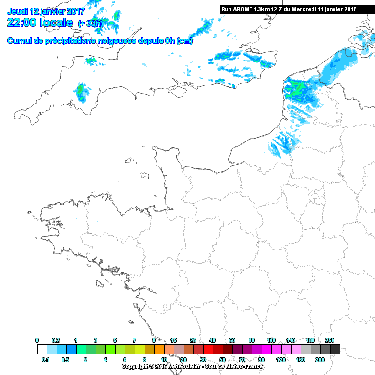
36 minutes ago, jamesbhx said:
Total predicted accumulations as of tomorrow morning. AROME 1.3km model. 00z run.
yay arome has come on board for my corner.
-
2
-
-
1 hour ago, snowking said:
So, let's take a look at where we stand in terms of Hi-Res modelling this evening then:
Conclusion - Clueless! As to be expected when you have 4 uncertain variables to play with
I don't mind, they all give me snow except the last one, that's good enough for me.
-
1
-
-
1 hour ago, Ben Blizzard said:
GFS 12Z looking good for our corner tomorrow evening, and again early Friday morning.
-
1
-
-
At the min, met office gives me sleet at 19:00, then Heavy snow at 20:00 and 21:00, light snow at 22:00.
-
2
-
-
9 minutes ago, Norfolk_N_chance said:
Quite concerned about the output as previously mentioned, northerly winds not good when combined with spring tides, we could easily see a repeat of December 2013 and that was catastrophic for this area
Agreed not good timing for a northerly on Friday, plus the pressure is quite low. I hope the surge and high tide do not coincide.
-
23 minutes ago, Changing Skies said:
Hold up the Euro4 12z does quite convincingly what we see accessible to public domain only goes up to noon! 10cm possible for elevated areas of SE England . Posted by @snowking
wow love the look of that.
-
1
-
-
2 hours ago, Backtrack said:
Worryingly though, the ECM is on its own
It is now, but the 6z GFS had a similar pattern.
-
31 minutes ago, frosty ground said:
Interesting feature running down the north sea coast.Interesting in some respects, however I think it may be an idea to watch out for sea height's on this day two. Not sure if the spring tide and winds coincide, but the risk is there.
-
1
-
-
11 minutes ago, paget said:
Sorry
Lol it was humour. You are welcome, nice to see you back.


SE & East Anglia Regional Weather Discussion 12/1/2017 11z ---->
in Regional
Posted
Yep 0.4 just here, and small snow from the start, no big flakes, but heavy.