


Polar Bear
-
Posts
1,891 -
Joined
-
Last visited
Content Type
Forums
Blogs
Gallery
Events
Learn About Weather and Meteorology
Community guides
Posts posted by Polar Bear
-
-
Urm we’ve had a fair bit of snow.. more than the first beast from east maybe? I would say a good 6ins? But haven’t bothered to go outside. looking at the radar though think we are coming out of it. What was forecast for most of the day I think has got through. Wasn’t expecting that much. It is though I think quite wet so not sure how today’s temps will fair with it etc. It is quite beautiful and am tempted to get up and go for an earliesh walk . Don’t think the neddies will be ridden anyhow this morn. Enjoy those to the west of me. You’ve fun to come .
-
 1
1
-
-
10 minutes ago, Mapantz said:
Surface temps are about 5C. Soil temp is still at 8C at 20cm.
Not here they are.. down to 0 degrees. Yeee haaaaa.. got to be in it to win it. ???
-
16 minutes ago, Mapantz said:
Surfaces had dried out completely here. The ground is a sandy loam to around 5ft, then gravel under that, so water drains away instantly, no matter if 2 inches falls in an hour.
Ah ok. Quite lucky then. ??Sorry meant fortunate. .. am tired.
-
3 hours ago, Mapantz said:
Managed 12.3°C today. Even got the first lawn mow of the year in.
How on earth did you manage to mow the lawn after all that rain? Ours is on a hill and drains well but is saturated. Do you have a special machine?
-
10 minutes ago, Mark Parsons said:
If it turns out anything like this it could be interesting.......

Wow selective chart .. it’s pretty much made a bee line for GB.!
-
17 minutes ago, Nights King said:
Well had a quick glance and models look okay south of the M4
Still a chance of snow and very cold still game on...
I think those northerners need a break from cold snowy weather its been a hard winter for them to endure
See what the pub run brings...
Even the BBC weather man said chance of snow for south. Wow. I almost detected convinction in his tone.
-
2
-
-
11 hours ago, *Stormforce~beka* said:
I don't want any more snow please thank you
Froze on the walk to school. Seems it around 3c. Didn't realise it was so cold.
I’m with you on that. It should be time for G&Ts in the garden soon not whisky by the fire. ? ...
been a tad overworked this week with long days so have ignored this forum and forecasts. Driving home tonight was a bit of a surprise as didn’t realise so much rain was due. Had to take the back rural roads. Rutted from the snow and plenty of standing water..and flooding - oh and one point down to about 3metres visibility with fog. What was that all about? It is rural Berkshire hardly the height and remoteness of Dartmoor.. oh well good old British weather never ceasing to amaze us.
-
1
-
-
For @Jayfromcardiff
https://www.facebook.com/groups/469757349806738/permalink/1604985282950600/
and anyone else on here from Wales .
and all of us! Did make me smile. Hope all the gritter men across the country get some rest soon.. although most of those in the north and Scotland wont yet ?
-
2
-
-
People are trying to get to the Moors with sledges!!! Don’t!!!
-
1
-
-
6 minutes ago, snowysouth said:
I work in a care home. I've just gone out but come back in. I can't even get past my drive. It's like a skating rink. I NEED to get to work. It's freezing rain now. Horrendous out there
Very much a dilemna but if you can’t physically get in. You can’t. You are under a warning ⚠️. They have health and safety rules your work place will need to abide by and forcing your staff to come in because it is their shift, against national warnings and your safety will be breaking those rules. Stay safe. (They will have staff already on shift who can’t leave the care home! ) stay safe.
-
2 minutes ago, coxxy22 said:
Am I right in saying the met office issued a red alert for the south,sw,and Wales 10 mins ago for heavy snow and blizzards ???
no it was earlier today - red was extended into tomorrow today too
-
23 minutes ago, snowponies said:
They were not happy bunnies and the oldest was really freaking out due to the incredibly high winds. Will do my best to get to them in the morning. They've got tons of hay but water buckets are frozen solid
offered some warm water but no takers. Only an inch at home, think we might of had some freezing rain since I got back as car is covered in ice! How much do you have @festivalking
Oh bless them - not surprised. Dam water freezing over.
Make sure you be careful if you go tomorrow, but maybe call a local farmer or someone to go with or meet you there?
Road outside my friends (main road) with the horses is blocked with traffic including a horse box stuck with horses on it. My friend has checked and all ok, they have hay and water etc. But what a night mare - pardon the pun.
-
3 minutes ago, Man With Beard said:
What's it like?
cold I should image? Freezing even? maybe..
-
15 minutes ago, Bring Back1962-63 said:
Don't worry. here's an update:
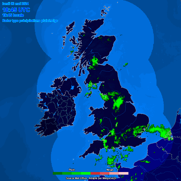
NW radar - screenshot at 1715 Live radar UK Live radar France Infra red satellite Standard satellite
Surely you've got some snow now? Have you looked out of the window
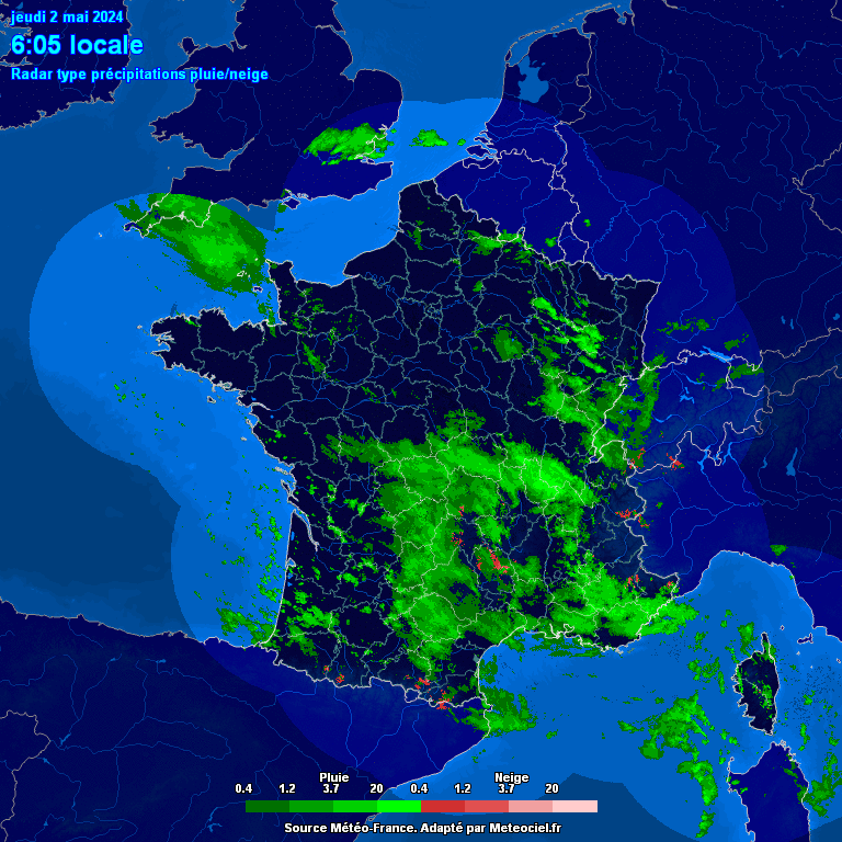
(sorry - not nice). Now, nobody should be overly concerned (just yet) about the green (wet snow/sleet/rain mix) and the blue (rain) on the NetWeather screen shot. The green is actually showing up over Exmouth now and I can assure you that we're having heavy snow and the temp is sub -4c. What we have is the less cold air (close to 0 c or just above) climbing over the dense cold surface air. Radars peer through these layers and pick up some rain or sleet at a high level and they are pretty inaccurate over sea areas anyway. Even if it is raining up there (which I doubt at this stage), we would either get freezing rain (possibly a dramatic ice storm) which would present some other serious dangers (I've posted about the 48 hour January 1940 event earlier this week on here and at length on the MOD last week which started and ended with a blizzard) it is very likely to turn back to snow again as the heaviest precipitation arrives very soon. Let's put everyone on here who, like me, lives on the south coast, on "freezing rain" watch. If the NW radar does pick up on freezing rain it should show up in a dark purple or mauve colour, The Meteoceil (France) radar shows simple snow or rain colours . Where NW has that green, Meteoceil have red or now white colours which shows very heavy snow. For those further east, see how that area coming out of north France is expanding. The extreme east of Kent, Essex , Suffolk and Norfolk should all be in line soon. Those purple, pink and even the white colours on the infra red satellite are the areas of much thicker cloud and usually contain the much heavier precipitation. When that reaches the Channel it will provide even great instability. Even if the snow turned to freezing rain, it would almost certainly turn back to extremely heavy snow. as it engages our deep cold block. Those darker colours are taking a little longer than expected to arrive - currently around Nantes and through Britanny. Perhaps another hour or so until we see the dramatic expansion of the dark red and white colours on the Meteoceil radar - it's already getting pretty dramatic out there in the Channel.
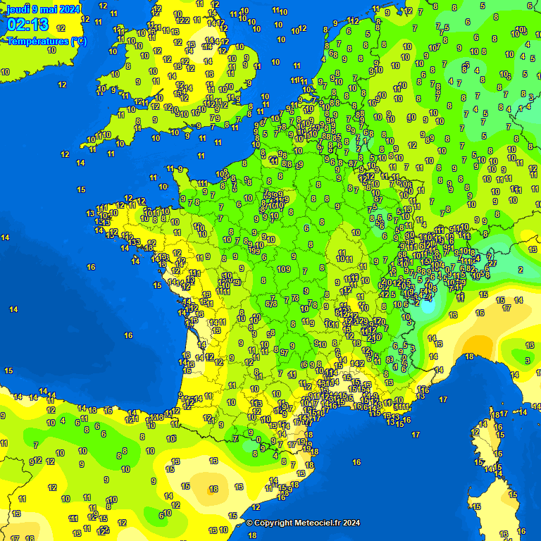
UK: Live temps GIF - last 24 hours Dew Point temps Wind chill temps Wind direction
France: Live temps GIF - last 24 hours Dew Point temps Wind chill temps Wind direction & strength
The south-west is warming up to -3c
When viewing the GIF 24 hour temp changes you need to bear in mind the min/max range. Less cold air has been making more northward progress this afternoon but there are still some sub zero temps in north-west France. The deep surface cold is still intact there (just) and it is only the warmer Channel (6c to 8c) that moderates that temp. Then in the UK we still have deep surface cold and the upper temps are not as extreme as they were last night. The winds around Emma are interesting! West in south-west Biscay and southerly in south-west France but easterly further north and across the UK. This means that even on the south coast, the surface air is still being sourced from around Belgium (eastwards) and still mostly coming over land with little moderation from the sea - this should prevent the slightly less cold air moving in until the winds veer to a more southerly quarter. Finally the pressure - our faithful Scandi HP is still there in situ but has declined . it'll be fascinating if it can hold on and forces Emma to stop moving northwards - the ideal scenario will be for Emma to drift east and that will enhance the easterly and ensure that the cold spell is prolonged for those of us that want that. I would love some clear sunny skies after the blizzard but we may still get a thaw and a slushy mess.
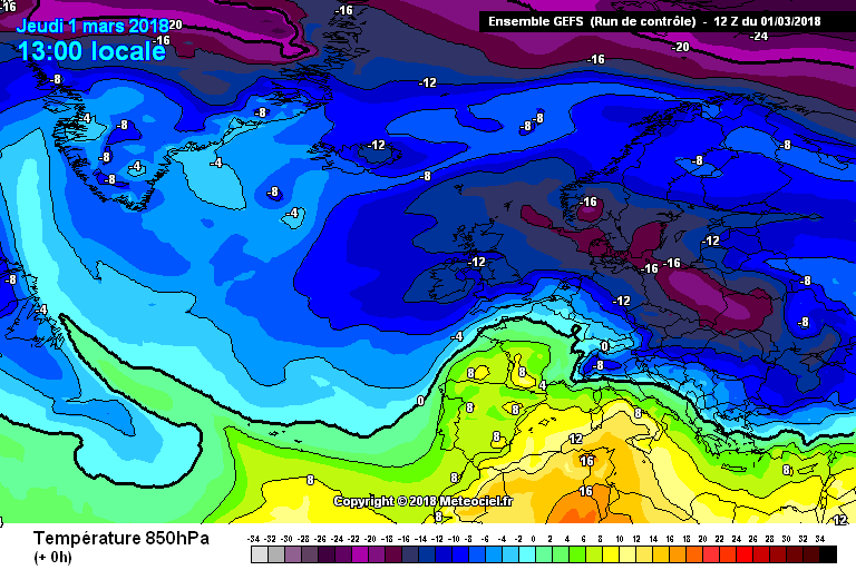
GEFS 12z T+0 1300 Mar 1st 850 Temps Live Euro Pressure GIF - last 24 hours Euro Pressure
STOP PRESS: THE MET O HAVE JUST EXTENDED THE AMBER WEATHER WARNING TO AS FAR AS LONDON. WHEN WILL THEY EXTEND THE RED WARNING? SURELY VERY SOON (OVERDUE IMHO).
Finally, I have near "white out" conditions now. The proper blizzards is well underway. This is the less cold air climbing over our deep surface cold. A classic undercut as in Feb '78. Enjoy
David
You are just awesome. Thank you for posting and especially for taking the time to post.
-
 4
4
-
-
14 minutes ago, snowponies said:
Holy batman Pogo stick, just got back from the horses on the moors and in all my 26 years I have never experienced weather like it! Think I have driven and walked through my first blizzard! Couldn't muck out the horses as the wind was so strong it took it all out the wheel barrow. Couldn't see more than 2 meters in front. Over 1ft snow drifts, absolutely crazy! My car is blooming amazing and on one snow drift I drove through I felt the side of the car tip up. Not going to forget that in a while!
Good to hear you and Neddies are ok... Bless you. Well done. Bet they were pleased to see you?
-
2
-
-
whose from Poole - visibility looking not so great atm... https://www.fjbhotels.co.uk/liveview/?cam=2
-
6 minutes ago, snowponies said:
Us horsey lot are hardcore ? couldn't break their outside buckets this morning and had to use a rock to break them, then pick out the ice with my hands, brutal!! My girls are just outside lydford near the firing ranges and clients horses are between Bridestowe and sourton.
They do regulate their temperatures so well which is why I haven't rugged the two oldies, even the clipped one got too hot in a 300g so she's in 100g at the moment. Would you still be able to get to yours?
I know and its the whole bare hands on metal frozen gate we casually do! Ha hab - tell you what has made poo picking outside easier! Come up in one go! ha ha. Ours at my friend's home as they are hers. School though is frozen, and no access to paddock but they have their "sun terraces" so to speak outside the stables so they can have some outside walk about..all has been plenty gritted and they have loads of haylage. Both were clipped a while ago and both like yours regulating temps well.
Ps don't know if you do this or are doing it or can practically do it, but we gave ours a bucket of really warm water as well - drank that in seconds.. so maybe worth taking up some when you go as some tend to not drink so much water if it is too cold.
-
3 minutes ago, MrNooo said:
You need someone with a 4wd tractor if you can find a friendly farmer, I suspect that if they have livestock they will be dealing with their own problems mind!! It won't be the depth of snow but the drifting that will be the problem with a normal 4x4 where a decent tractor will just plough straight through, got one sat in the drive with snow plough on the front but alas a tad far away me thinks!!
Think you will be very in demand MrNoo later - your neighbours must love you! Snow Plough tractor...
respect.
-
1
-
-
1 minute ago, snowponies said:
Only one is rugged up who is clipped but the other two aren't, they are very hairy and considering they are in their mid/late twenties, they are lovely and toasty. They've got a lovely semi deep littered straw bed too so think they will be ok. I've always had them at home in snow so not used to not being able to get to them! They have giant turnips in the car waiting for them ?
Fabulous. Yes it is a worry I think not being able to get to them. Yes we were surprised the other morning when it went into the double minuses just how toasty they were - almost too warm. Think their natural body regulating temp thing is kicking in. Amazing really. Good luck and keep me posted! Us equines need to look out for each other :).. PS West Dartmoor where abouts are you - I have a horse friend in West Dartmoor too with a huuuge 4 x 4
-
2 minutes ago, snowponies said:
Thankfully they are in a large barn with option to go out too so if the roof comes down they can get out. It's sheltered from the wind too. Clients horses I have left stabled. Got a neighbour's number just in case! Will go at 2.30pm but if it gets bad will turn back home. Good thing I topped all my horses haynets up so fingers crossed they'll be ok!
If you go back shove a load more hay on the floor, we did on ours... Be safe going back and give the neddies a carrot from me
-
1
-
-
10 minutes ago, snowponies said:
Bit concerned now, have gone home and cancelled my jobs on the moors as that wind is unbearable! I live in the orange zone but my horses and a client's horses all live in the red zone! How good is a Toyota rav4 in heavy snow??
As long as they have plenty of hay, water (put a tennis ball in to help stop the freezing over) and shelter/rugged up they should be ok. Think sometimes we worry more than we need to. Ours were well toasty the other night with the 450g rugs on. Don't know about the Toyota Rav 4...is there anyone else nearby to go do the checks?
-
1
-
-
15 minutes ago, Rapodo said:
As expected big downgrade on met office app for Poole oh well.
Interesting... did you know about the window application for checking the weather? Most houses have them but it does require looking up and away from the screen and out through the window application?
-
1
-
-
Didn't METO say midday to arrive on our shores? 10 mins to spare they were slightly out! ......
...just kidding - bang on right METO -
1
-
-
2 hours ago, Bring Back1962-63 said:
EARLY MORNING REVIEW
Good morning and welcome to "Spring" everyone
This is an "interim update".
The big day is here. I've had my first settling snow since moving down here permanently 3 years ago. Here's a very modest pic. Many who missed out completely so far should have had a little overnight and right now.
From Inside 0700 0705
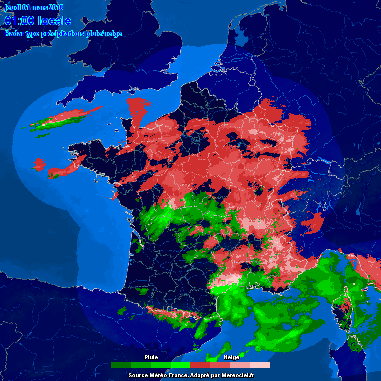
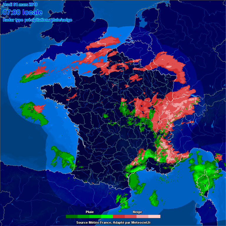
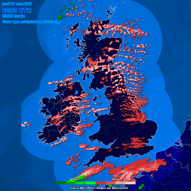
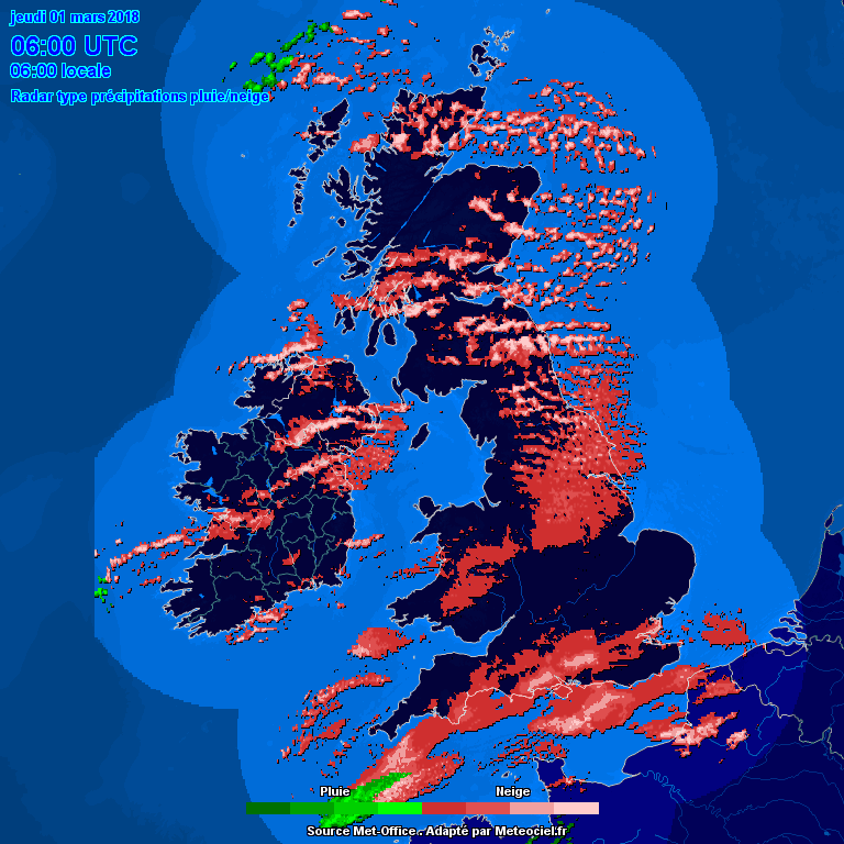
Before I starting writing part 3 of my report (see part 1 on page 170 and part 2 on page 184 for loads of live charts) I will do a quick round up of current conditions and overnight developments. Most of these charts are at fixed times so that comparisons can be done later in the day but I'll start with the live radar and satellite ones for reference..
Before a few of you start panicking, this snow is NOT the main event which "should" develop later this afternoon and into this evening (as forecast yesterday) and we have our own "red" warning from 1500 today. There have been a few misleading local forecasts which seem to have suggested that this is the main event now and push it all through at breakneck speed (wrong!). The Met O seem to have a better handle on this and the BBC may well start to regret dropping their service. The red warning (and the previous amber warning) are totally at odds with the local BBC forecast.
0000 GMT 0600 GMT 0100 GMT 0500 GMT
The snow that pushed eastwards and then northwards into France yesterday was quite well ahead of storm Emma. That initial band of snow over France has weakened and dispersed. The "all France" radar does not show the Channel snow properly. What happened was that the leading bands of snow from France moved across the Channel in the small hours and engaged with the remains of the streamer. This has introduced some additional moisture and the band has expanded and "may" become self sustaining and bridge the gap to the main event later today or we may get a lull as it pushes northwards. So look at it as an appertizer before things really wind up later on
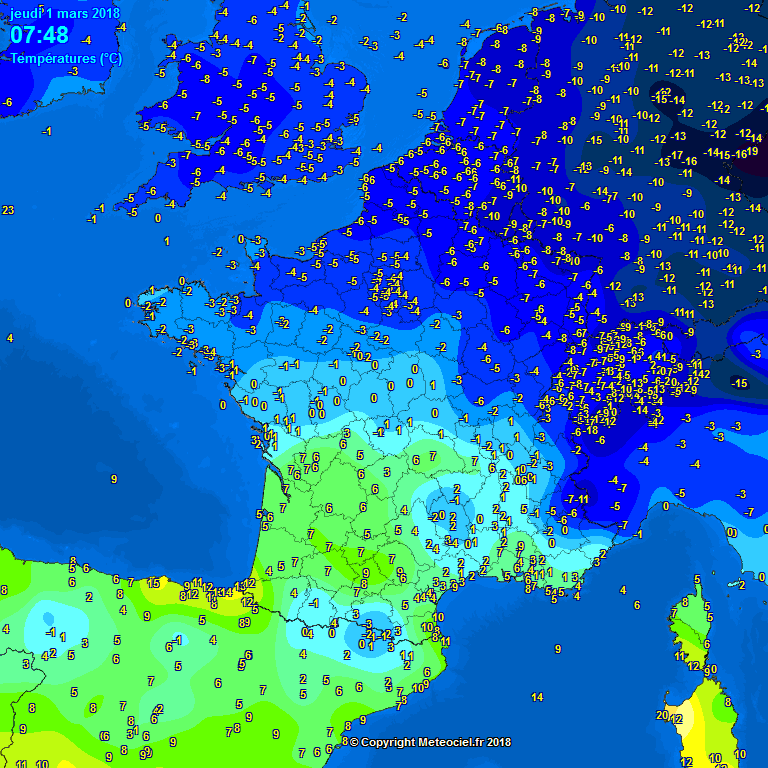
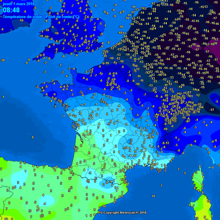
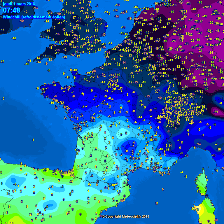
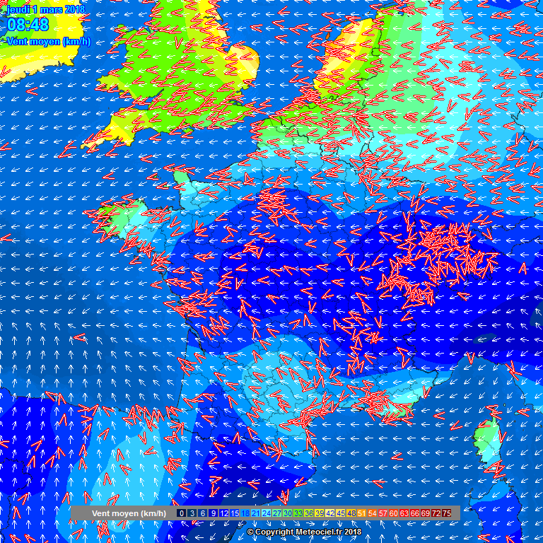
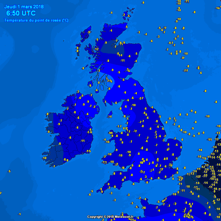
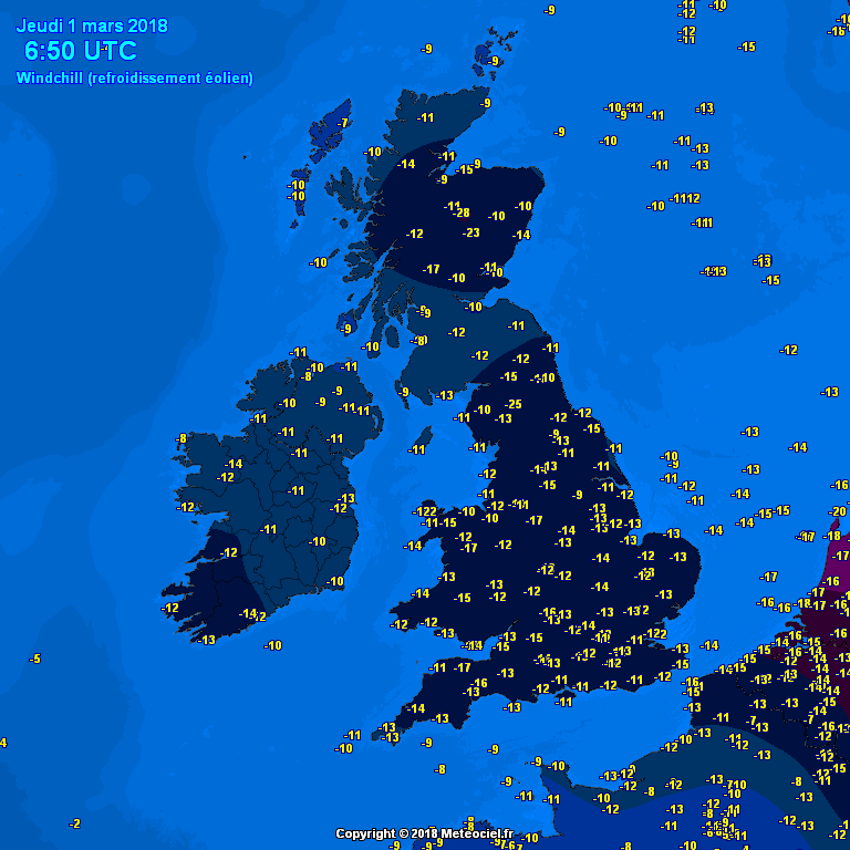
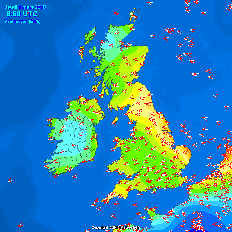
0800 Round Up:
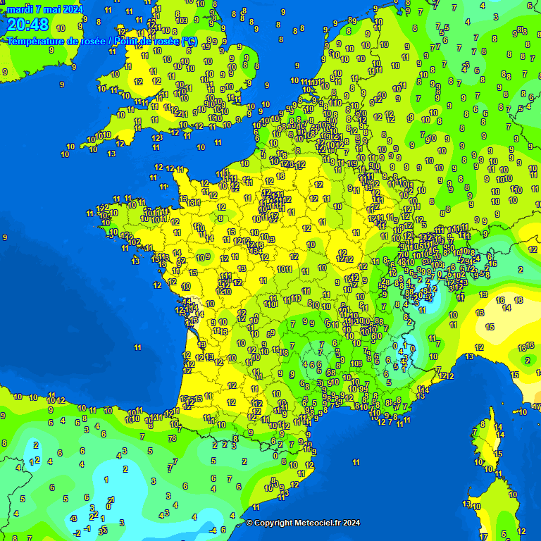
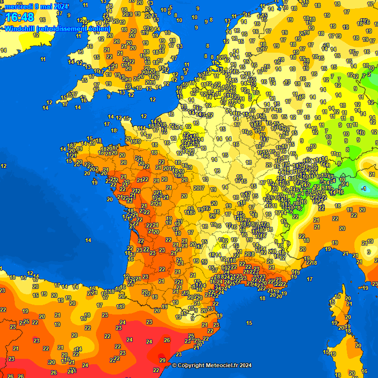
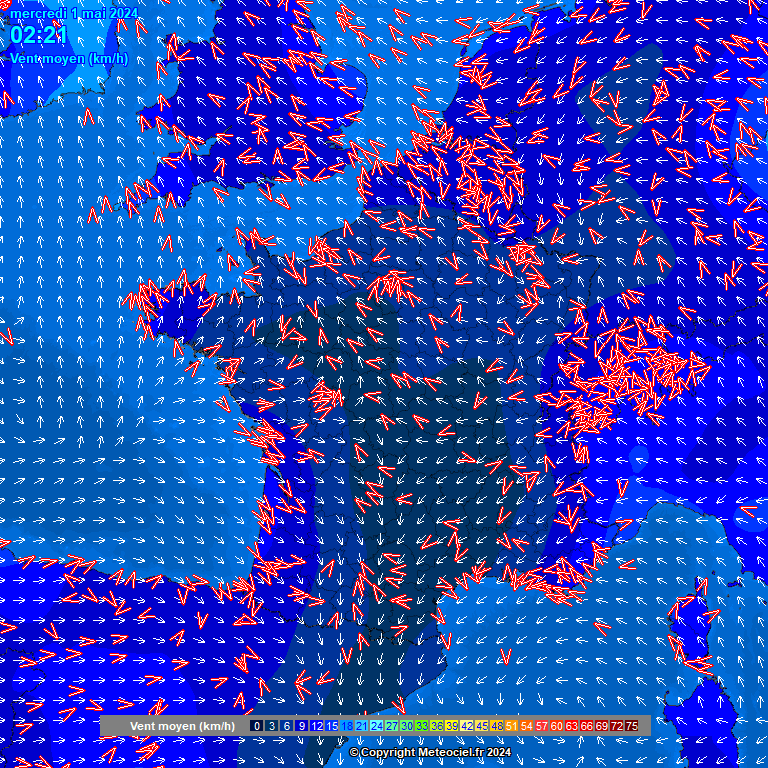
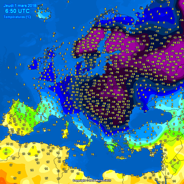
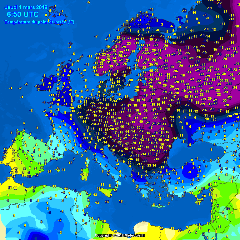
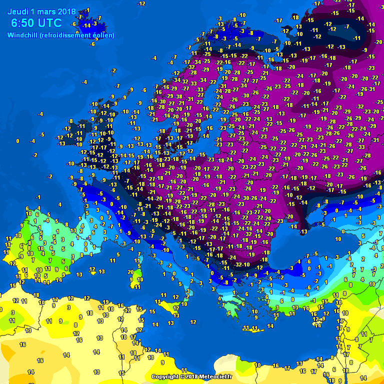
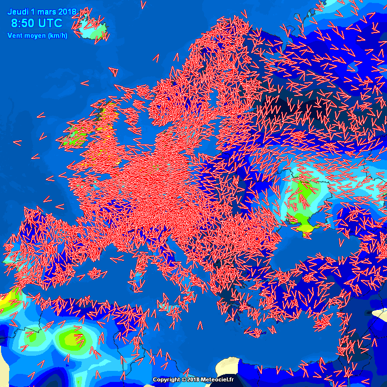
France: Surface Temps Dew Points Windchill Wind
UK: Surface Temps Dew Points Windchill Wind
Euro: Surface Temps Dew Points Windchill Wind
Wind Chart Explanations:
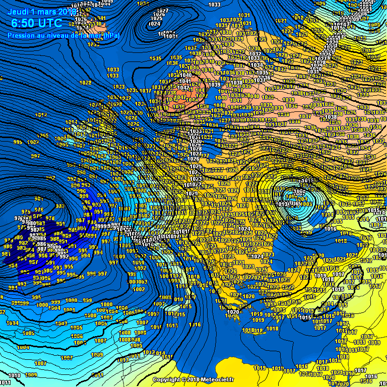
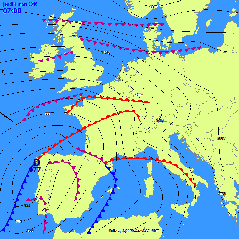
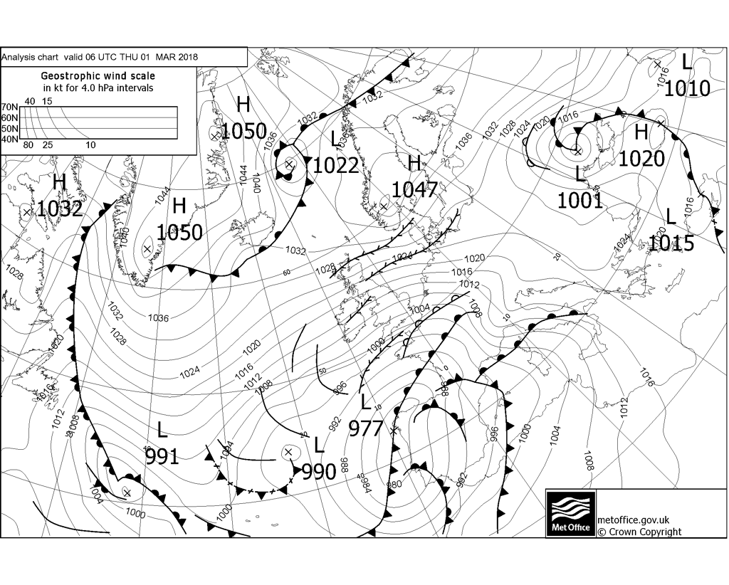
This maps show the average wind in real time recorded by weather stations in France and neighboring countries. The red arrows represent the direction of the wind of the stations, and the white arrows (only on the all France chart) represent the direction of the wind calculated at any point of the map according to that of the stations. The colour represents the average strength of the wind. These are the most recent observations of the present time and not forecasts.Pressure: 0050 GMT 24 hours to GIF Live Fronts & Troughs 0700 Mar 1st Met O Fax for 0600 Mar 1st
Brief comments:
The milder air has made very little northward progress in France during the last 12 hours and the area of southerly winds is still confined to the south west of Biscay. The deep cold over us is still in place and today will see some March lowest max temp records broken.The Scandi HP has only declined slightly and remains in situ (for now), maintaining the block, holding off the northward progress of the LP. The flow has veered slightly more towards the east-south-east overnight with east-south-easterly to easterly winds continuing and strengthening. The Met O fax shows the "ghost" warm front ahead of the other fronts. This is only upper level less cold air climbing well over the surface cold - I discussed this in previous posts and will pick up on it in part 3 of my main report later this morning. Prepare to be snowed in
David
@*Stormforce~beka* here's an update on what this morning was all about and what is to come..
-
1
-
1
-


 respect.

 ...just kidding - bang on right METO


South West and Central Southern England Regional Weather Discussion 03/03/2018 Onwards
in Regional
Posted
Think we maybe clearing soon, as it moves up and slightly more west. Definitely seems to be a nice streamer setting up in the channel for some to the west. You are in for some heavy continuous snow. Just waiting now to hear about some power cuts. Won’t be long now?