


Yorkshirepudding
-
Posts
333 -
Joined
-
Last visited
Content Type
Forums
Blogs
Gallery
Events
Learn About Weather and Meteorology
Community guides
Posts posted by Yorkshirepudding
-
-
17 minutes ago, Weather26 said:
But too late for a White Easter on the grounds of the fact it would have had to have happened on Sunday.
There’s still chance of Snow showers throughout the weekend I think more inland with elevation so maybe not for everyone but still some could get a white Easter so don’t write it off just yet. And with 4 days still to go slight upgrades towards cold could bring more in play.. having said that it could still go the other way so it’s worth keeping an eye on especially if you have travel plans..

-
1 hour ago, Craigers said:
Looks like a southward correction to me
Yep. Could be interesting if this comes off. large Accumulations over the course of Monday/Tuesday I still think the spine and slight elevations will cop for the worst but looks like it’s increasingly moving in favour for snow even down to lower levels. Still a long way off but interesting to watch it pan out.
-
 1
1
-
-
Looking interesting going into next Monday. Especially for the spine of the region as mild air bumps into cold air could be significant accumulations and transport issues if this run continues... It might not last long given the time of year but could give one last hurrah for the coldies.
-
1
-
 1
1
-
-
On 19/03/2018 at 23:42, farmans said:
I tweeted Sheffield Western Park weather station enquiring about the official depth from Beast 2 and they confirmed it was 17cm but said it was tricky to measure owing to drifting.
The official figure for beast 1 was 15cm.
So beast 2 wins and I think locally it didfeel like that.
That depends on where you were situated. For my location the first Beast won hands down with 16” that fell in 3 days and then came the gusts of wind that created mayhem to the roads especially higher and more exposed routes streamers around Kent again created major problems south east and most of the North east even in land area got cut off for days that’s not to mention the read warning for around Glasgow & Edinburgh with snow deaths reaching in access of 50cm landing in 24hours. Then came Storm Emma for much of the SW and Ireland again dropping some massive totals for places like Exeter & Cardiff again some places seeing 50cm+ adding in the high winds caused total grid lock even major motorways ground to a halt stranding some ppl over night. No buddy I’m pretty sure the first Beast won.. lol. However for certain areas Beast two brought more like central and southern east so for you and definitely @reef Beast two won the day for you. But as a comparison as a whole Beast 1 won.
Now let’s see what Beast three brings hopefully a white Easter would be nice since we can never get a white Xmas..
-
19 minutes ago, jam said:
It’s a warning ... an “ it might happen”
I understand it’s a warning and it might happen maybe they’ll update the warning areas also. I’m just suprised is all in some of them areas community’s will be cut off already that to me warrants a Amber warning as it’s a take action is all I’m saying we have an Amber warning for our area today and judging by the radar which I’ve watched all day that area has been hit harder than any of ours just confuses me a little is all?
Edit: In my post I put “ has “ it was meant to read “ Hasn’t “ I wasn’t saying why have we got a Amber Warning and the other area Hasn’t I meant why hasn’t the other area also got one... I do apologise for the Confusion ?
-
I’m really confused as to why an amber warning has been provided for this area. It’s been getting hit hard all day even more so than the Amber warning for our region..
-
43 minutes ago, Sunny_AS said:
What an amazing gap that some of us have!! ??
I feel your pain. Still plenty of time but we could just be in that unlucky area. Just need the wind to shift ever so slightly more. ?
-
1 minute ago, cheese said:
Had a number of heavy showers recently, in succession, so we now have a covering.
I think Sausage must live in a city called Leeds but a different country..
-
Could get interesting tonight into tomorrow for the whole region..
-
16 minutes ago, LeeSnowFan said:
and that would go inline with the amber warning for south yorks! roll on 4pm
It’s definitely looking that way at the moment but areas just north or south of any streamers could only see a dusting yet their in the Amber area also and will call it a bust. When In theory it’s not a bust because the Forcaster have absolutely no way of nailing down exact areas especially with the snow coming in as showers and not organised bands of Rain/Snow they can only tell you where they think the most at risk areas are “ Currently “ things could change with a slight shift of wind.
-
The area between Hull and Sheffield I suspect will be one of the hardest hit areas as shown on the radar screen shot I’ve provided below things are already pepping up somewhat and as the day light starts to drop along with Temperatures I suspect this area to have a decent covering by the morning. Be good to see pics from people in that area?
-
1
-
-
@vizzy2004 your location is right on my streamer line what you get I get with the current wind direction. Good to see heavy showers inbound thanks for the Photo.
-
1
-
-
2 minutes ago, Barking_Mad said:
BBC says no snow at all between 4pm and 11pm. Met Office says heavy snow between 4pm and 11pm.
Who will win?
If your going on apps these are terrible they’ll change minute by minute. However the Met app is by far better that the BBCs, last Beast I got around 16” in three days on my location I think the BBC app showed a couple of light snow showers throughout those three days it’s absolutely Useless so I think it’s safe to say if your going on the Apps the Met will be the closest however it’s still not a given. ?
-
1
-
-
40 minutes ago, Sunny_AS said:
Are we expecting some sort of a trough to get this warning??
The forcast is for showers to band together in places to give slightly prolonged periods of snow for those lucky enough to catch them and obviously as the sun starts to go down and temperatures with it will help these accumulations. Not all the places in the Amber area will receive those streamers it’s more about nowcasting and radar watching. Remember these areas are only a guild some places outside the warning area may also get the heavier/iest Showers/Streamers.
-
1
-
-
27 minutes ago, IPredictASnowStorm said:
That's more like it ?
Another channel Streamer...? The last one was a great example from the first Beast probably one of the best I’ve seen on the UK radar. Would be good to see another one similar it was a thing of beauty.
-
3
-
-
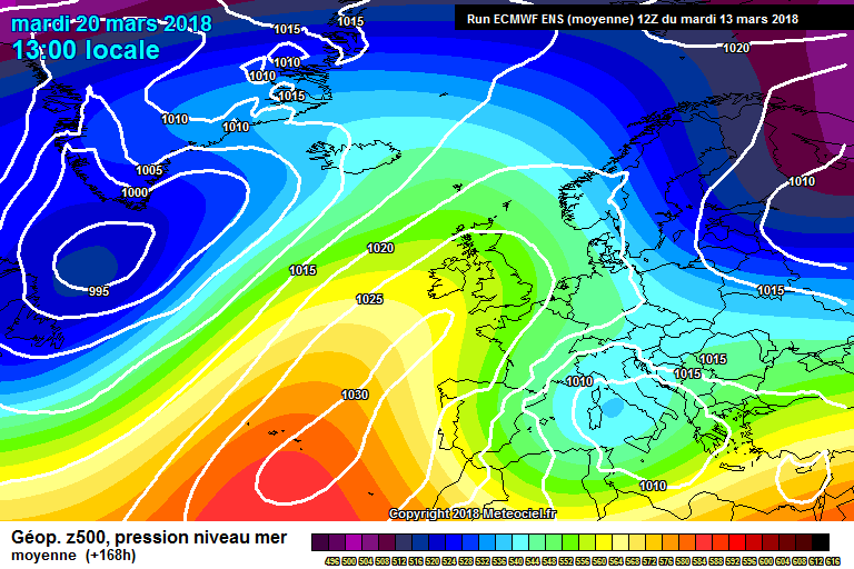
1 hour ago, Mike Poole said:
Well it is positively icy in here after the 12s, and no one seems to want to post the chart that seems to represent the tipping point, so I'll take one for the team. Here's the ECM ensemble mean at T168, clearly sinking the high.
But was it ever really going to be more than a cold snap, this late into Spring?
To be fair the first Beast was only a Cold Snap that caused chaos for 3-4days. I’ll take another ?
-
8
-
-
So as things are set to get a little warmer at times for the next week or so the models are showing a return to cold for the second half of March. Maybe bringing more heavy snow especially for our Region and further north mainly inland and on higher ground but not exclusively. obviously things can change but with the jet still far south it’s very possible we could be in for more supprises as we move through March and into April. Maybe I’ll stick around on here for a few more weeks yet..lol.
-
Yesterday the weather system was meant to go to the south hitting mostly the midlands and South Yorkshire with snow for the latter and higher ground if you go by the tv forecasts It then shifted slightly to include the majority of the region. I must admit I wasn’t expecting what has fallen especially the way it has stalled slightly over us. Been snowing in my location for several hours now maybe 3” has accumulated over that period and it’s still snowing loverly little surprise to the morning not expecting it to last very long but still nice to see a long with yet another snow day.
-
1
-
-
@terriertake care my friend after this week I will be doing exactly the same. hopefully this is signs of things to come winter wise..
And for anyone else reading this when I say that I mean proper winter winters not the problems it’s caused / Causes as all weather types have there own hazards..?
-
2
-
-
5 minutes ago, Allseasons-si said:
I wonder which way that lot is heading out of france!
http://www.meteociel.fr/observations-meteo/radar2.php?region=uk&mode=1
See I knew there was something in France.. haha.
-
7 minutes ago, Allseasons-si said:
Oh!,you mean the Neatherlands
there you are
Sorry yes i meant Belgium and the Netherlands.. That’s wine for you lol.
-
Yes remember guys what you see over the uk now isn’t what you will get when and If it moves this far north that will be well over Ireland the fall we would get if it does make it this far north is still in France or the North Sea.. it runs a lot further than the radar can see..?
-
Just on the topic of this system moving up from the south..
Most the region should see some falls not a great deal but some places In the south of our region could see a couple of inches maybe slightly more over the higher routes the further north a little lighter maybe afew cm in places especially the higher ground as temperatures still remain below freezing. As we all know with the surface temps as low as they are light snow builds up quickly and with this system been so slow moving it could be quite prolonged and cause a few further problems. Sunday another system looks to be pushing its way in a similar fashion with snow on the higher ground and inland and sleet further towards the coasts maybe rain or freezing rain mixed in..
Lets see what happens as these few days have really been about Nowcasting but I does seem at least a few of us will have a little finale to the weeks events. Looks like I’m resorting to a bottle of wine ? at home instead of mine normal Friday beers with the lads.
-
So after about 80 hours of heavy snow showers coming to an end for me late morning yesterday.. Now the high winds creating havoc more so on slightly higher routes even though the snow had stopped its actually created more severe weather. Cutting off more community’s like myself. Bringing major motorways to a standstill for many hours over night in the freezing cold. I can only hope no more deaths have been caused and my thoughts go out to the families and friends of those that have lost their lives.
We have had our fun now and I’ll be more than happy with a thaw. Although I hope it’s a slow thaw otherwise it’s going to create another hazard for some in the form of floods that’s the last thing we want to see is people losing property due to floods.
There’s still going to be a battle ground for us and we may still get heavy snow at times with frosts over night and ice as this transition into spring slowly progresses but these heavy snow storms if we get them will be more like we are used to with the snow melting quickly.
saying all this I would of loved a grand finale with Storm Emma and maybe we still might get the dregs as the wind slowly drops aiding the system to push further north Tonight/Tomorrow. But I’m hoping the farmers will do u great job again as they always do so I can at least go to the Pub for a pint of two over the weekend that would be a perfect end to an exciting week for us cold lovers.
-
1
-


Yorkshire & E England Regional Weather Discussion
in Regional
Posted
As I quoted earlier inland and elevation most at risk things can obviously change to include more low lying areas or vice versa. We get that your not a cold lover and each to their own however I would take snow any day to torrential cold Rain.
The fact of the matter is set ups like this can produce significant snow fall within a small time frame... having said all that I do agree this doesn’t warrant the “Beast From The East” warning as this is just a standard cold spell that effects us somewhere most years.