


frosty ground
-
Posts
4,589 -
Joined
-
Last visited
-
Days Won
1
Content Type
Forums
Blogs
Gallery
Events
Learn About Weather and Meteorology
Community guides
Posts posted by frosty ground
-
-
So whilst people are wondering what will happen in the Pacific in a weeks time the GFS is throwing out a rather potent but short lived cold spell with the potential for some white stuff even in the South East

A feature of this winter is low to track over the UK form the North West.
Also of note is that by day 5 the cold air is back in Scotland and working its way south. Must be having a good skiing season up there-
 4
4
-
 1
1
-
-
- Popular Post
- Popular Post
That's one rather large Mid Atlantic block-
16
-
As Nick says -
Run P17 from the GFS 06 is pretty nippy and snowy...... But these runs are in the minority but a consistent minority.
-
7 minutes ago, Had Worse said:
its gone to the other extreme now with telepathic thoughts and crytic replies. No one wants to overstep the line and be accused of ramping.
Well the MJO is forecast to move through phases 7&8.
The ECM and GFS which produce the above are showing signs of amplification.
The MJO signal (forecast) is backing up the model output that is not MJO.
-
57 minutes ago, Summer Sun said:
UKMO extended keeps the milder set-up
For England and Wales only
-
1
-
-
Over an inch of snow here now and it's blowing about a bit...
Looking at the radar its going to Stop soon so np rain gor a while at least
-
Snowing but fine snow but its sticking at least
-
Looks like snow outside but its hard to tell with the fog temps above freezing thou
-
Snowing for over an hour and its not really settling.... except in existing cover
-
Light to moderate snow here now
-
1
-
-
Classic mamchester rain shadow effect in action today.
-
Two flashes of lightining and thunder with snow
-
2
-
-
Some big showers about and they are heading this way for once
-
2
-
-
Looks lively around blackpool
-
1
-
-
2 minutes ago, Chris.R said:
Sounds very positive. Shows a period of lying snow cannot be discounted. Perhaps the Met will issue warnings later.
Already a warning for Sunday
-
2 minutes ago, Deep Snow please said:
Looks like another let down here, precipitation completely disappearing from the Irish sea or falling to the south of us, just as we were starting to get snow. One of these days it'll happen.
South of you north of us....... if you live on the M62 you might be lucky
-
1
-
-
On 18/01/2018 at 11:56, frosty ground said:
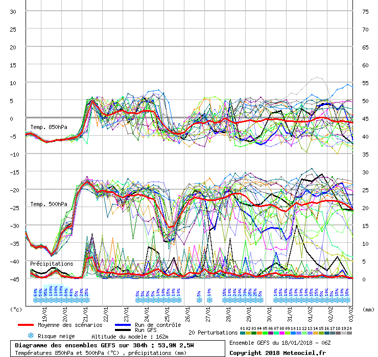
A distinct split in the Ensembles around the 28th
These look like sets of ensembles from December and earlier this month, a 5 day mild spell and then a dip to below average. If the pattern repeats we should start to see the jet take more of a NW/SE trajectory allowing more PM air over the UK.
So the split on the 28th has gone leaving the milder output
But the 25th has now firmed up on a 2 day cool down, it's almost like history is repeating itself.-
1
-
-
Showers have sank south a bit over the last half hour. now hitting more of Greater manchester.
Need to lose that southerly element to the wind thou -
Nice rash of showers just to my north, just cant catch a break with these shower ATM.
-
I am surprised at the lack of showers and whilst they had intensity on Tuesday they lacked longevity and today they lack both.
-
1
-
-
19 minutes ago, James M said:
Just had a driving lesson in the snow, very interesting! Roads getting covered quite quickly and hills are nice and white
And in oldham no snow at all....
-
Streamer looks pointless
-
Everything is white now.....
-
2
-


Model output discussion - mid January
in Forecast Model Discussion
Posted
12z following the 06z so far, colder air digs further south quicker by day 5.
Also there is a lot of nothing going on between Greenland and Scandinavia.