


frosty ground
-
Posts
4,589 -
Joined
-
Last visited
-
Days Won
1
Content Type
Forums
Blogs
Gallery
Events
Learn About Weather and Meteorology
Community guides
Posts posted by frosty ground
-
-
2 minutes ago, karlos1983 said:
hmmm, interesting

We now have a rain event for the majority.
Mild sector.... is back.
-
 1
1
-
 1
1
-
-
4 minutes ago, Day 10 said:
That'll be rain then
Not seen anything other that Rain for coastal location for Saturday.
-
First chance to test the New BBC App Vs The Met Office APP for my location
BBC has sleet and rain (with temps at least 1 degree higher) Met has light snow and some sleet
What Model is the new BBC web site using? -
20 minutes ago, chicken soup said:
Really hope this front gets here on tuesday...it has a feb96 look about it ..my all time favourite snow event...over a foot here.
Front looks like it's gonna die a death. (IF Twitter)
-
So the Atlantic go in and quickly bring n it PM air with a runner.-
1
-
1
-
-
The Atlantic gets in on this run, but the block is still there, (Big change by this point) -
Greater Disruption
It's also worth noting the difference in the low coming out of Canada.-
1
-
-
A better angle of attack from the Atlantic, if that front can approach vertically aligned with the UK then that's a recipe for a big snow event. -
1 minute ago, karyo said:
By Tuesday evening the 6z gfs sets up a northwesterly with -10c uppers. If that happens, then I can die happy!
Anyway, the 6z is more amplified than the 0z which is a relief. The UKMO has me a bit concerned this morning but let's hope it will get more amplified this afternoon.
I spotted that it has a look of january 4th 2010 about it, not as cold thou!
-
1
-
-
Just now, tight isobar said:
Incoming- going to be an epic 6z..here
Excluding the slight correction west it looks the same as the 0z.
-
GFs back the Azores high a bit west compared to the 0z. -
4 hours ago, CreweCold said:
Look at the charts posted...we're in a mean westerly flow by day 6...
Might be cold (most especially at night) courtesy of stagnant cold pooling from E then via NW but by day 6 we're struggling on the UKMO, GFS and GEM. In fact, the GEM turns out really quite zonal.
Day 7 GFS is ok though...50/50 as to what happens next
Key to remember, -8 uppers might look pretty on a chart but for low lying NW England -8 uppers of a PM origin don't always deliver snow (as many have found out this winter). -8 uppers from a polar continental source and we're laughing.
A mean westerly flow running into an entrenched cold pool, with additional cold following on behind.
-
More Disruption Incoming-
1
-
-
high pressure over Scandi now on the 12z vs low on the 06z.-
1
-
-
12z Vs 0z
night and day difference between the 0z and 12z ICON.-
3
-
-
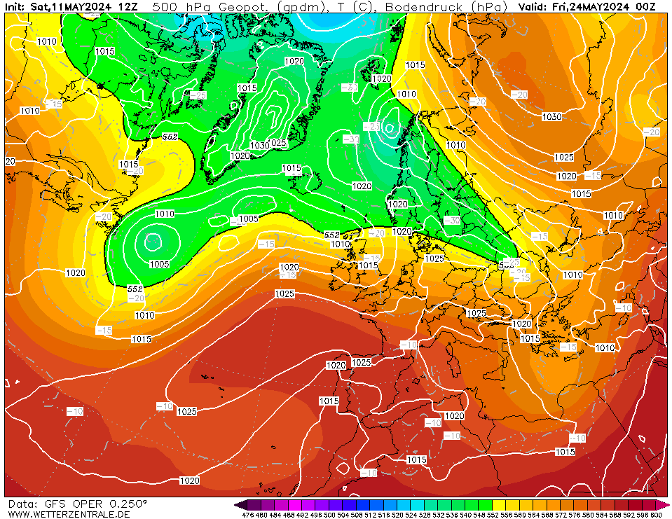
More of a mild sector makes it across the UK by Thursday next week, i think we can thank the Azores high for that. -
6z Vs 00z Icon
Thats a big shift (pretty much what Steve has said already)-
2
-
-
Good covering of snow maybe an inch will it last till the morning thou.
-
1
-
-
Covering off snow here
-
4 minutes ago, Optimus Prime said:
So going by your mentality, if you don't understand someone's point of you, you compare them to your wife and accuse them off winding other people up? What's fundamentally wrong with someone injecting realism/different perspectives into the discussion?
The people at The Daily Star would think Christmas has come early if half the people on here offered to write the weather section for them
I've read all your post and you need to explian to people what you find exceptional or intresting or standard February weather.... because without that no one knows what we shpuld ve co.paring the current charts too.
-
7
-
-
54 minutes ago, Paul_1978 said:
Yes I did thank you. I can no longer edit my post.
However point till stands - nothing particularly noteworthy <240.
Would be delighted to be proven wrong.
What would class as noteworthy....?
-
Main course...?-
6
-
-
1 minute ago, Optimus Prime said:
Sorry but I'm not taking your word for it.
- It is pretty bog standard to February.
-good debate mind
Not much debate to be had when one poster starts whining that he cant see what all the fuss is about.
-
5
-
1
-
-
1 minute ago, Banbury said:
What do you mean the rest of the run, its not half way through ( 12z) or are you talking about the 6z
It is on Wetter


Model output discussion - proper cold spell inbound?
in Forecast Model Discussion
Posted
GFS 12z pretty quick return to Atlantic. Not yreat mid section.