


damianslaw
-
Posts
17,467 -
Joined
-
Last visited
-
Days Won
86
Content Type
Forums
Blogs
Gallery
Events
Learn About Weather and Meteorology
Community guides
Posts posted by damianslaw
-
-
2 hours ago, Jordan S said:
GFS also shows a similar looking low pressure system for 2nd November, likely to be very wet and windy, but the possibility of stormy weather for southern areas if these charts do materialise, interesting track coming more from far to our south than the typical west or southwest.

Yeah scrap the higher pressure building close to or over southern areas for the first few days of November. Looking much more mobile and unsettled for all infact more unsettled than the rest of this month..
but turning cooler than recently, again though possibly more northwesterly winds becoming established for the second week of November with wet and windy weather likely to continue, so plentiful rain about even for southern and eastern England, with snow possibly falling for Scotland later on into the second week perhaps to lower levels too in any heavy bursts of precipitation with signs of the continent also cooling down to a more significant degree.

Just a hint the trough is setting up to align NW- SE, forcing low pressure to dig south and south east..
-
In recent years mid Dec to early Jan has often been very if not exceptionally mild, especially run in to christmas. 2014 brought a bit of cold post christmas, 2017 ditto, only 2020 since 2010 has brought anything more notably cold same period and again posr christmas but lasted well into Jan. Would be refreshing to have a colder period pre christmas lasting into New Year.
2009 was the optimum but perhaps too much to ask.
-
 2
2
-
-
2 hours ago, jules216 said:
The pattern its already there a while and we Can say its nailed Down at least another 10 days with little to no model discreppancy and even lala land is not offering any change or very little of it. I would call that near 6 weeks period of this obscure warm T850hPa in central Europe courtesy of the spinning self serving low pressure west of Ireland. Its amazing isnt it that under LA Nina we were supposed to have a north westerly autumn yet we get 3 RD year in a row a Nino like autumn with just the Euro high in La Nina, what we get is La Nina like second half of winter = mild. Isnt it just typical atmosphere just find its way to mild mild mild Europe.
No surprise after the exceptional heat of summer, the european landmass is taking an age to cool down, however as hit Nov both the polar regions and continent undergo much more rapid cooling and sudden changes can take place. A euro high in Oct means warm, by mid Nov it can trap cold air at the surface much more easily.
-
5
-
-
17 minutes ago, Relativistic said:
Perhaps I'll be proven wrong, but I can't help but feel that at some point, perhaps in the next decade, we will see a brutal shot of November cold.. PV formation heading into late Autumn seems to be more and more perturbed as the years go on due to ever-increasing excess heat post-Summer*, whilst cold can still build further north as the polar night falls. Our default position in these setups is undoubtedly in mild sectors, but at some point one of these crazy perturbations has to become reality? Thoughts?
*Please let me know if this is a recency bias!
It happened in Nov 2010!
-
2
-
-
Good Autumn day, sunshine, light winds and very pleasant 14 degrees. Great walking weather, anyone on half term break in Lake District.
-
7
-
-
31 minutes ago, itsnowjoke said:
12c now at this time roasting
Nothing unusual for a Oct evening. Southerly and south westeely airflows should result in such temps in October.
-
6
-
-
2 minutes ago, Frost HoIIow said:
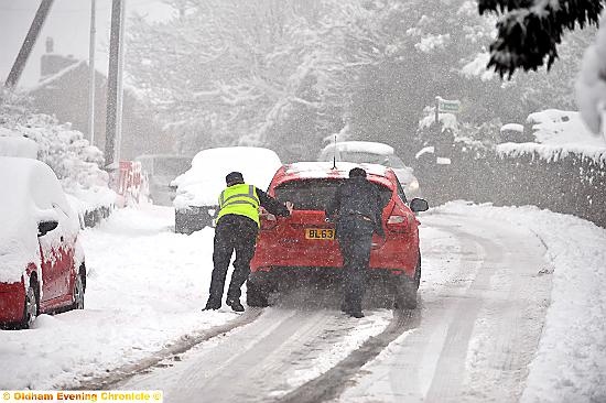
Depends where you are in the region though. Had a couple of snow coverings in those first two winters you mention that brought more than just a dusting as seen below. Had a decent fall in March 2016 too. Not winter technically speaking though but not far off.
In pictures: Snow turns Oldham into winter wonderland - Manchester Evening News
WWW.MANCHESTEREVENINGNEWS.CO.UKSnow has been falling across the borough and you've been sending us your pictures of the scenes where you live.
Chaos under a blanket of snow
WWW.OLDHAM-CHRONICLE.CO.UKTraffic chaos, suspended bus services and the closure of around 80 local schools followed the fall of up to 30cm of...Only remember one snowfall winter 15-16, about 2 inches mid Jan, thawed next day. 2016-17 almost same thing happened same time period. Perhaps had a dusting or two Feb-Mar 16, it turned colder but mostly just frost. Most of winter 16-17 was just dry and mild.
-
6
-
-
12 minutes ago, Frost HoIIow said:
Only decent fall of snow here last winter, well technically it was Autumn was the few inches we had at the back end of November. The winter itself though one of the poorest ever, right up there with 2013-14. Albeit less stormy than that winter. It's just alarming that two of the most rubbish winters of my lifetime have occurred within 10 years of each other. At least in the "mild phase" of the late 1990s to late 2008 we had topplers that gave an inch or two a few times in those winters. Nowadays even that's getting hard to come by!
2016-17, 2015-16, 2019-20 nearly as snowless as 2013-14 and last winter, 5 shockers in 10 years. 2018-19 not much better, and 2014-15 below par as well. Only 17-18 and 20-21 I'd class as average.
-
7
-
-
6 days time and my sunset time is 16:40! Always a shock to the system.
-
16 minutes ago, Midlands Ice Age said:
Thanks for te above Aleman....

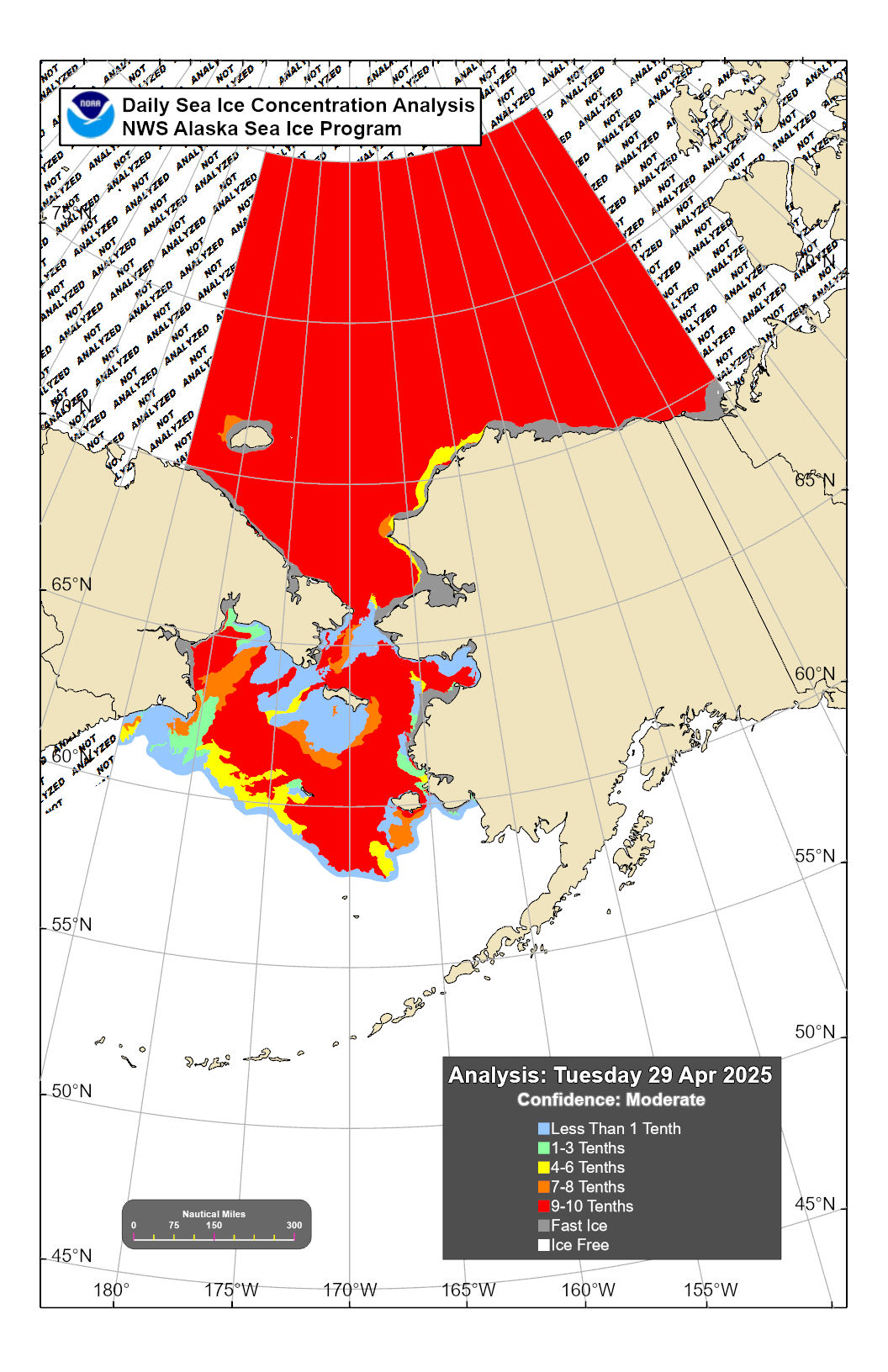
Masie has just updated and snow/ice extent is behaving much as I predicted in my posyt on friday with the change to the weather circulation patterns now taking hold.
The high pressure now dominating the weatern Arctic and the low pressure systems aligning themselves along the coastline into Northern Russia. The only slight problem for the sea ice might be the slight extension of the low pressure into the Yukatan pennisular which might bring milder winds backinto the ESS and Chukchi.
So, as Aleman predicted, the snow has moved down the spine of the NA continent and with high pressure developing behind it in the Eastern Northern Pacific aligned North South, I can see a fairly cold North America for a little time to come.
Similarly for the Russian continent, over the weekend we have seen the depressions pushed southwards along and into the coast line. With the cold air from the Arctic being pushed into place into Central Russia, more widespread snowfalls are now going to happen, pretty well up to Moscow. Expect a continuation of the chart shown by Aleman above with good snowfalls.
Now to sea ice ...
I last reported that the sea ice refreeze had slowed (fri),.... as the change in weather conditions took hold.
Well this process continued over the weekend, with gains of only (+28K) on saturday. This has left the comparative Masie chart well down on last year (though still well above the previous 4 years still) -
However, today the sea ice started to expand/contract in the way I forecast on friday, with a gain today of 128K Km2.
The main area which held steady or contracted were as predicted in the ESS which actually fell (-22k) over the 2 daya s the predicted easterly took over, and pushed the ice away from Wrangle Island again.
However nextdoor Laptev began to fill in the holes left towards the coastline and gained (+22K) in the 2 days. Kara (again as predicted) is now freezing westwards (towards the Severnya Islands (+5k)), and the Berants sea (+6K) increased to nearly 20K Km2 as the ice pack moves ever closer to Svalbard and the outer Siberian Islands.
The star of this area (again as forecast) was Beaufort which had a flash freeze connecting it to Alaska/Yukon (+74K). I expect Beaufort to now continue with a quick freeze.
Steady ice gains in North American Arctic with gains in the CAA (+31k), Baffin (+18K), and Greenland (+18K) over the 2 day period,
Lastly to temperatures -
CR has seen a small reduction in world temperatures over the couple of days, and the outbreak of cold in the weatern/central US looks impressive, also the Arctic is now cooling again (see below).
and
The drop in the Arctic 80 degrees and above was once again during a period of slow ice growth (over the weekend).
The actual temperature reported today has dropped below 260K for the first time at 258.0K. This translates to an average of -15C though still about 4C above the 1970 - 2000 average.
So we are just at the start of the new wetaher regime....... where does it go next?
MIA
NW North America seems destined to be the colder part relative to average in north hemisphere.. Europe always milder!
-
1
-
-
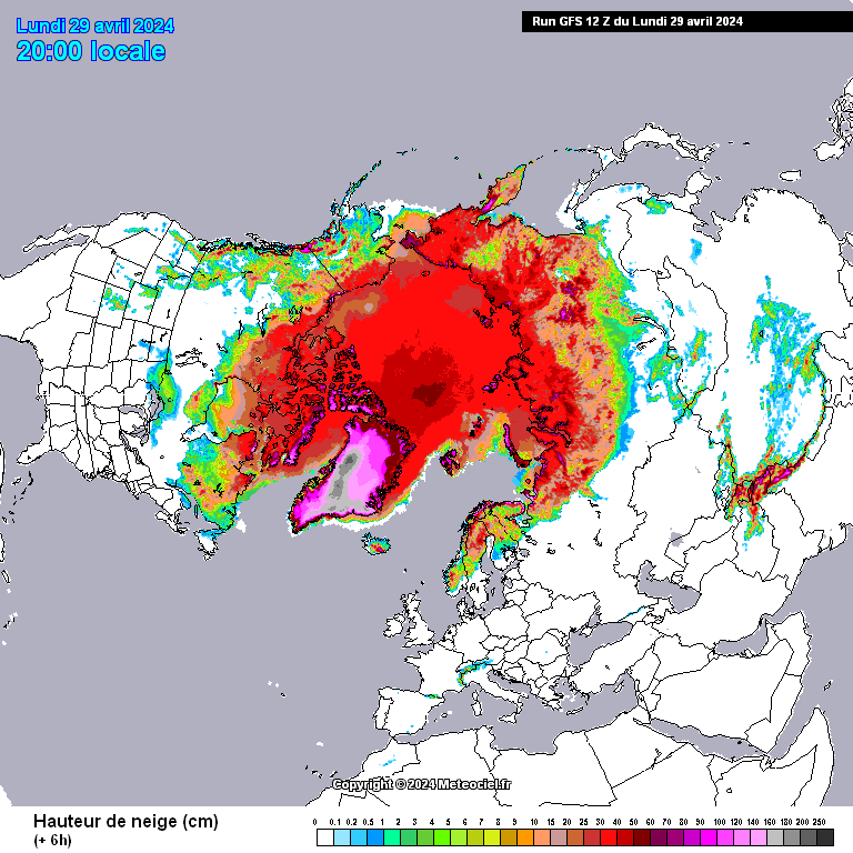
5 hours ago, Aleman said:
To get back on topic:
There's lots of new snow and ice after a bit of a pause. The main pack has linked to Alaska/Yukon and the low that brought those northerlies has driven widespread snow down the western USA, almost to the Mexican border. There's a bonus the latest system bringing some westward expansion to Russia. Meanwhile, Laptev is filling in.
Encouraging to see rapid expansion along northern most part Russia into Scandi - if the precipitation shown on the map is all snow.. I remember it doing this in 2009, rather have snow into scandi than much of central/southern russia.
-
1
-
-
1 hour ago, Day 10 said:
Good afternoon all,
Bit rainy here at the mo, mild though.
November GFS coming into range, keeping a keen eye on mid-month as the Met seem to suggest an early shot of Winter. As CS has already stated they even mention the S word, interesting to mention that so far out. Goes along with the suggestion of a cold start to the season from the long range models.

6z shows a marked change by 2 weeks time, heights transfer west and we open ourselves to much more of a polar influence.. mind the models were showing this happening for now a couple of weeks back.. delayed..
-
6
-
-
Take a look at the synoptical charts of Oct and Nov 2005 - this is the type of transition that we may expect this autumn, a very mild Oct and first half Nov, then colder secon half.. the synoptics this Oct very same to 2005.. and later Nov saw high pressure transfer to the west and there was much northerly influence.. I'd take another Dec 2005 as well, never espevially cold but like 2001 seasonal with lots of dry frosty weather and a bit of snow.. incidentally 2001 produced a very mild Oct and then northerly influence at times in Nov.
-
1
-
-
1 hour ago, Don said:
Lets hope December does not have a 2015 feel to it too!!! One consolation is we were in a super Nino in late 2015 and combined with a westerly QBO, mild was very much on the cards all along.
With so many months above average, the chances are we will have a colder month at some point and hopefully that will happen this winter!
The year as a whole has been different to 2006 and 2015..
-
Not feeling this October at all, where are the crisp days with cool mornings.. early in the month it looked like we might see a more seasonal October after the cold latter part to Sept. Alas second half of the month is turning into one long very mild rather wet/ dank gloom fest in the main... still the autumn colours are now in full splendour. I do hope we see a change in November.
-
5
-
-
6 minutes ago, Nick L said:
But it doesn't. They said drier, not dry.
Yes high pressure perhaps setting up to the NW but then low pressure moving down on its NE flank pulling the high westwards.
-
1
-
-
1 minute ago, Don said:
Ref to 2009, there was a central based El Nino (Modiki) event, so I don't think this year is really comparable. However, I do not know off hand what the ENSO state was in late 2005? This October is similar to 2005 though which was the second warmest on record after 2001, I believe and rather wet, too. We seemed to go from late summer to early winter that year, with little autumnal weather as September was also very warm!
November 2005 was interesting, a very mild first week, then high pressure took over by mid month, and the second half was notably cold with northerly winds... and snow for some.
-
3
-
-
I think the Jan 1940 snowstorm was the most significant in the Lake District in the 20th century.
-
2 minutes ago, Joe Snow said:
Very mild but it felt warm walking the dog wearing a winter coat!


Its interesting how our turns of phrase change, when its mild from now on until about April we say warm, yet same temps in the warmer half of the year would be described as cold...
-
6
-
-
23 minutes ago, SqueakheartLW said:
Remember November and early December 2009 were mild and wet. Then we all know what happened after that. Same situation with November and the first 2/3's of December 2000 before a colder than average winter 2000/01 set in, admittedly not as cold as 2009/10 but mild autumn doesn't automatically mean mild winter to come.
Remember late October and then November 2005. We have very similar pattern now with persistent southerly winds and above average temps. Then a big flip mid November 2005 and snow was seen by late in the month.
Oddly I always think the chance of cold are much higher after a lengthy 'southerly very mild period as we are having now, all that heat heading north, comes back as cold heading south... warm air advection...
-
2
-
-
30 minutes ago, Joe Snow said:
There was a very warm spell around Halloween a few years back might have been 2017 or 16? Shame we didn’t see the amazing thunderstorms ⛈ further SE saw this afternoon but some warm autumn sunshine to end the day made up for the soaker of a start this morning. I’m hoping for a seasonal November - chilly days, fog, frost, the smell of bonfire smoke in the air rather than a mild wind & rain fest but we shall see

 ️
️ 
Wouldn't quite describe the late October sunshine as 'warm', has same strength as the mid Feb sun.
-
6
-
-
4 hours ago, severe snowstorm said:
Excellent, let's hope this sets the theme for the coming winter.
Very rare for Met Office to mention snow, normally say a wintry mix especially so early in the season, also coldest in north and west.. must be seeing a signal for an arctic NNW flow.. would be a big shock after what will be a very mild second half to October lingering into November. We shall see if it sticks with it, the colder forecast keeps being pushed back, but the met has been steadfast in mentioning it for Nov last couple of weeks.
-
8
-
-
4 minutes ago, SnowThunder said:
We're 2 years late on the once a decade snow fest, I'm sure it'll come any year now
2 years late? Reference to the charts posted.. seem confused. Looking at tye graphics and presenters would hazard a guess the charts are from sometime 2000- 2005, but can't recall any such snowy synoptic as shown during that timeframe.. Feb 04 or 05 possibly?
-
6
-
-
1 hour ago, Day 10 said:
At least you can relate then mate, sad state of affairs and getting worse.
Just give me one of these this Winter just ONE.
When was this?
We've low pressure in similiar position now, alas no cold air to tap into.. but rhe currwnt synoptics of southerly lows are increasing my confidence this year may be different, higher snowfall stakes.. we shall see.
Back to today, very pleasant for late October, sunny breaks, current temp 14 degrees, ideal walking/outdoor weather, good timing for anyone visiting Lake District, half term as well. Now entering peak autumn colour season, thankfully not much wind so fae blow leaves away early.
This is the last 'light' weekend of the year... make the most of it. Tomorrow looks quite poor mind.. so we have one more chance of a light decent weekend day in next Saturday.. believe me in 2 weeks everything feels very different, much more winter state..
-
8
-

.jpg.39ce6ab5df34acd01484873fec0c0a70.jpg)

.jpg.4e12417b3019fdc126b062aa695e25d3.jpg)
.jpg.fe6ad84886edd2090e359fcca6b80a0c.jpg)
.jpg.15fe20210b4e351d470eeb2300cecde0.jpg)


Topsy turvy months.
in Historic Weather
Posted
Quite a few such months, those that spring to mind:
Feb 12 - very cold first half very mild second
Nov 05 - mild first half, cold second
Dec 12 - cold first half, very mild second half