


wishingforsnow
-
Posts
312 -
Joined
-
Last visited
Content Type
Forums
Blogs
Gallery
Events
Learn About Weather and Meteorology
Community guides
Posts posted by wishingforsnow
-
-
GFS is improving by showing High Pressure moving in and changing the position of the low in the Atlantic so its no longer to the West of the UK. More runs are needed but judging by the Met Office current outlook and what Matt Hugo has been hinting, perhaps the jet will move north allowing for some hot spells post the unsettled weather during the middle/end of the week. ECM still looks like the quicker option for this path rather than the GFS which keeps the jet firmly south for the last week of May although the High Pressure does make tentiative inroads at the end of the run in FI. At worst regarding the prospect of a settled warm/hot spell it looks as though a North South split may develop with the jet running through the middle of the UK - giving at least the South access to the European heat and high pressure though it wouldn't take a lot of tweaking for it to spread to all of the UK
")
-
I'd say with the GFS the High Pressure arrival is delayed by a week but ECM would have it arriving earlier (much like what Matt Hugo was hinting towards a few days ago). Either way, if ECM is closer to the mark then so much the better, with GFS we would have to endure a last week of May with cooler and more unsettled weather (like 2006 and 2014) but if the High Pressure did arrive after that in time for summer then it's not so bad after all
-
12 minutes ago, knocker said:
Are you sure you haven't got that the wrong way round?
Isn't the 06z GFS run showing unsettled weather continuing into the last week of May? I thought the ECM runs for that period looked better. Although as mentioned before, the 06z is showing high pressure at the end of the run so if that came off it would be a silver lining at the end.
-
9 minutes ago, Man With Beard said:
Vorticity - yes that has been on my mind too
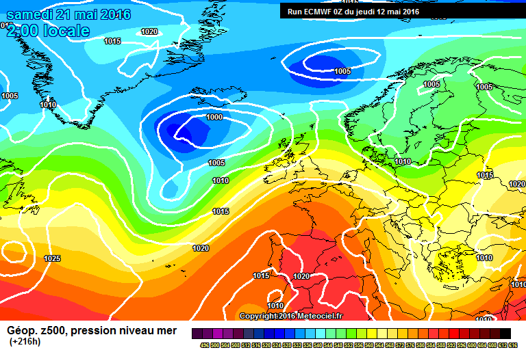
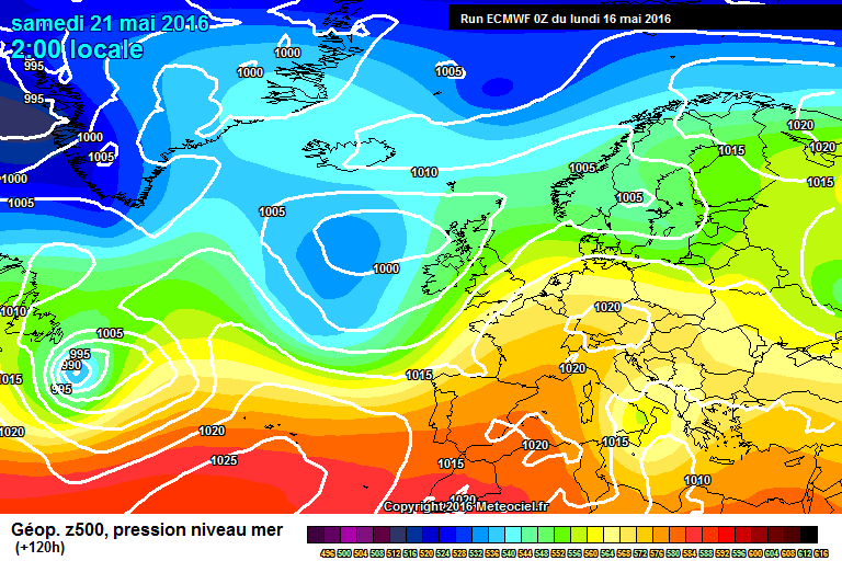
What we've seen in the past few days is on absolutely typical example of what the models often do. How many times have we seen this over the years? In the mid-long range, the models pick up on the macro-signal to push heights from the Azores towards the UK. Look at ECM charts at T240/T216 for the coming weekend:
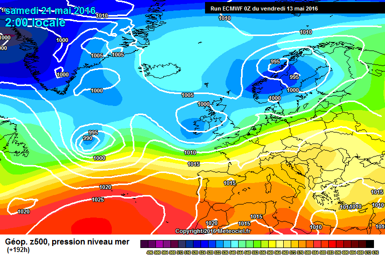
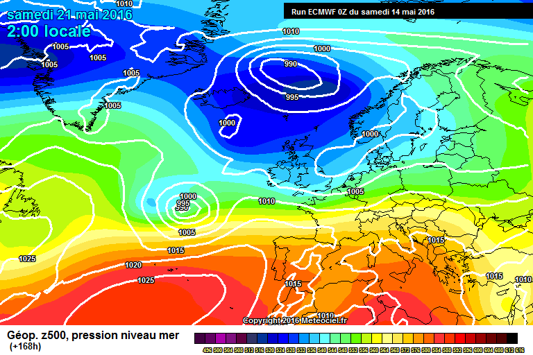
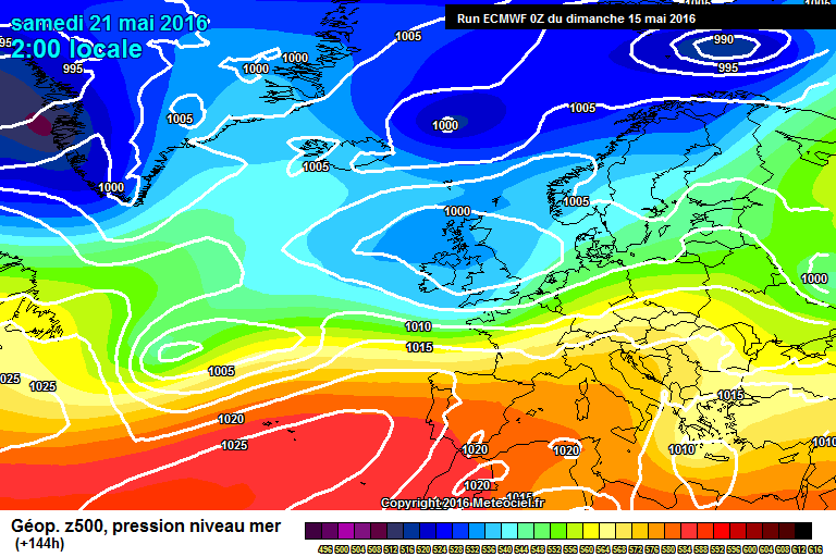
Then, around D6-D8, the models pick up on micro-signals, usually being extra disturbances coming from the Atlantic and, with heights being too weak to withstand, we see a turnaround - BBQ charts replaced with umbrella ones. As shown on the ECM at T192/T168/T144 below:
But there's often one last twist in the tale, and this is the one I don't really get - just before the point of no return, the models decide that there was actually some merit in the macro-signal after all and there is a slight backtrack on the dominance of the Atlantic. And hey presto - here's today's ECM at T120 - the bump of heights towards NW Europe is back:
I reckon that the T120 result is what happens 70% of the time when the T240-T144 pattern shown beforehand occurs i.e. when a decent pattern in the long range gets overridden in the mid-range, there seems to be a small bounce-back to the original pattern just before FI ends.
OK - in this case, the implications are small - areas to the south and east of London may get two decent, warmish days on Friday/Saturday, but apart from that it's pretty wet - time has gone for a big enough correction to allow more areas escape the unsettled weather. But when the weather seems on an Atlantic knife-edge, where it could go either way, I would suggest looking back at what the signals were in the T200-T300 range - more often than not, the weather will nudge back in that direction slightly, especially when there was a big turnaround between T150-T200. Doesn't always work but if you look for this over the summer I think you'll find this idea is right more than wrong.
That is a good analogy - seems the standard weather pattern for summer for an island between the Atlantic Ocean and Mainland Europe, but occasionally deviates due to extremely good or bad synoptic patterns respectively where either heights over Europe (1976, 2003, 2006) or the Atlantic (2007, 2011, 2012) is the dominating influence. Other than that the weather is in principle, a mixed bag of both for this isle during the summer season
-
5 minutes ago, northwestsnow said:
Looking pretty unsettled on the 0z runs with the jet progged to be unfavourable for any sustained ridging from the azores.
6z showing some very suppressed temps for the last week in may..
GFS also showed some very suppressed temperatures under the 'Northerly' during the weekend just gone. ECM were closer to the mark on that one rather than the silly cold the GFS was showing, so hopefully their output does end up being the form horse for the last week of May. GFS has a tendency to overblow low pressure and cooler weather too.
-
 1
1
-
-
On 15 May 2016 at 12:41, sundog said:
Accuweather--
'Bouts of rain will suppress heat in the UK and Ireland this summer.
Hp to the west of Ireland and the UK will keep extreme heat at bay and also direct Atlantic depressions between Iceland and the British Isles.....................'
Just for reference:
http://m.accuweather.com/en/weather-news/2013-europe-summer-forecast/13458131
What followed was the UK receiving the best spell of summer weather in 7 years
Regarding the tropical analogues, and record low Arctic ice - what will make or break the summer remains La Nina. Currently a flip to La Nina is still favoured to be August at the earliest with the most likely period being August into early Autumn. A lot of poor summers of the likes of 2007 were caused by a combination of an early flip to La Nina following a weaker Nino just before or at the start of the Summer season (hence the weather in Summer 2007 turning rapidly unsettled in early/mid May and pretty much staying that way until September) and the tropical analogues. If the flip to La Nina holds off until Autumn or late Summer, I think it will be at best a predominately very warm summer and at worst a mixed bag with good periods of warm weather
-
2
-
-
As it stands ECM's output is more palatable than the GFS (as it often has been recently
) so it is good to see that at the moment ECM appears to have the outputs with the most support as GFS would have the unsettled weather continue into next week whilst ECM is showing high pressure edging in again after the weekend.
-
1
-
-
8 minutes ago, phil nw. said:
There are suggestions that by day 10 the troughing over our locale weakens and the Azores high trying to ridge this way-the ECM run seems keener on the latter.
at this stage it's all very tenuous though with the south as usual likely to benefit mostly if it does happen.In addition later gefs indicates it may only be temporary.Certainly more runs needed before we can look forward to any late month warm and settled conditions with any confidence i think.
Currently the mean outputs still show a reluctance for a general shift north of the jet to leave it free and clear for our Summer friend(Azores High) to move in.Still shallow upper troughing being shown around our neck of the woods.
Yes, it's still very much a question of whether the upper troughing will clear allowing the settled and warm/hot conditions to stick around for a while or if we will be alternating between periods of warm/hot weather and cool Atlantic wet weather with a troughing v Azores High battle. Though it looks to me like it wouldn't be too difficult for the troughing to be cleared as it doesn't look very strong. Taking into account the heat across Continental Europe and the fact that the cold pool in the Atlantic is smaller compared to last year, the Azores High shouldn't have as much difficulty moving North over the UK as it did last Summer.
-
22 minutes ago, draztik said:
So if one model out of 6 (if you include the ensembles) shows a different outlook it's deemed uncertain? id call it an outlier, at best.
You still never know with an outlier, especially taking into account weather for 7-10 days out which is verging on FI. Sometimes an outlier has become more accurate than the majority of the model output, like the failed 'Easterly' of early 2006/2007 where all models apart from the GFS were backing the prospect of an Easterly arriving over the UK and it turned out the GFS output was the most accurate as it didn't happen.
-
10 minutes ago, Nouska said:
I'm not aware of any hi-res output for that far ahead but he'll probably have access to more of the ECM suite than we do.
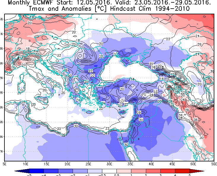
The EC32 was showing warmth for the last week of the month but as that run was initiated prior to the big swing in model output, it has to be viewed as suspect till the run next Tuesday.
This was central Europe on week two from the Thursday run - anticipating the pattern would include a warm UK in part.
This mornings EPS mean (day 15) has average 850 temps for the bulk of the UK and the Z500 is also looking to be the average north south divide - not seeing any indication of strong, warm ridging.
MSLP spread day 15
The big swing in model output for next week was due to the fact that the models had firmed up that low pressure was set to hit the UK in the next 7-10 days which was uncertain before but unfortunately looks set to be the form horse for next week now. Hopefully the next EC32 run and further model outputs won't see all prospect of hot weather returning for the end of the month eliminated especially as we'll be closer to the end of May by then. The jury is still out on that.
-
Ensembles for London are showing ground level temperatures rising after the 23rd May to high 20s by the end of the month. Also the main precipitation spike is between the 17th - 21st May tying in with the forecasted period of Atlantic low pressure:
http://www.theweatheroutlook.com/twoforecasts/ensemble-forecast.aspx
As @knocker said, two weeks away is FI so this warm up is by no means set in stone especially when there is so much uncertainty on it. Not even the weather for next week can be clear cut with model divergence how much the low pressure will have on the UK. High pressure is shown to begin to edge in again around the 23rd but anything after is deep FI right now. However I would hope Matt Hugo is perhaps referring to signals from high res model output.
-
21 minutes ago, draztik said:
That would depend on which model you're looking at. ECM ensembles trending to something very average into days 8-15; GEFS, on the other hand....
But after seeing the GEFS 12z update the other day showing a sustained high pressure for 2 weeks solid, only to capitulate on the next update, I know where i'll be placing my money.
GEFS change frequently depending on unexpected changes in weather patterns in the atmosphere. We've seen this before where models have been slow to pick up on a previously unforecasted spell of weather deviating from the previous output however the NOAA anomalies and ECM runs did show a slightly more unsettled period for next week/low pressure building in the Atlantic a but there was a lot of uncertainty (and still is) up until yesterday as to if and how much it would affect the UK.
There is still uncertainty as to the impact of this low pressure next week - UKMO has reduced the impact with something more anticyclonic whilst GFS has low pressure at full force. Judging by the supposed recent 'Northerly' modelled which a week ago was supposed to bring back cooler single digit and freezing temperatures to the UK this weekend, I doubt the impact of the low pressure will be as bad as some models are currently making out. The end of the runs for next week do show High Pressure and warmer temperatures edging in again.
-
Regardless of the models presenting an unsettled spell of weather from the middle to end of next week, it looks like high pressure will return for late May early June. I'd say we have much better synoptics entering June and the Summer season than we did last year
-
Some very mixed model output compared to the past few days. However we are still talking about weather for roughly a week's time, again, like the 'northerly' which was supposed to make temperatures drop 15 degrees today and into this weekend, I suspect the supposedly extreme unsettled weather for next week may not be as bad as the models are suggesting i.e constant heavy rain, disruptive storms and strong winds every day. A slightly more unsettled period was always on the cards but the silver lining we can take from this is, as things stand, the heat/warmth/settled weather still looks likely to return end of May and beginning of June. As for the Met Office long range - the final part of the forecast suggesting a return to unsettled after settled weather again is in deep, deep FI weatherwise so subject to change. Hopefully the return of the heat and warmth at the end of this month and for early June still upholds. A trend for Easterlies over the UK could also mean that unsettled cooler spells of weather this Summer are shorter with longer settled spells, especially in the South, despite heights to the NW.
Just touching upon something Tamara has mentioned before about a 'reload' of weather patterns being more likely this year as we enter the summer - in particular with the heights to the NW and melting ice in the Arctic. Also referring to @damianslaw's comment above, I do agree that we may see long hot settled spells interpresed with cooler Atlantic dominated weather rather than a lengthy settled and very warm/hot spell during the summer 1976/2003 style. On the other hand more like 2 week warm/hot spells broken up with occasional Atlantic low pressure periods inbetween but not one weather type necessarily dominating the weather like hot and dry in 2003 or cool and wet in 2007/2012: which were both caused by extremely fortunate or unfortunate weather synoptics, respectively. More like 2013/2014 as a recent example. I'd take a mixed bag but good summer over a warm Spring with a pattern breakdown ushering in cool, wet weather for the Summer any day.
-
2
-
-
21 minutes ago, TomDav said:
GFS 12z shows HP building in strongly deep in FI
So a brief weekend cooldown, followed by a North South split as a few model runs don't have the Atlantic low pressure next week reaching the South and after that ever growing likelihood that temperatures will rise and perhaps giving way to settled weather across the UK as we enter June. Nothing to complain about here
-
1
-
-
On 10 May 2016 at 19:25, markyo said:
So much better weather today for working,fresher and really easy to get on with things. Don't get me wrong a shocking day in many areas if your lucky enough not to be working,but working in warm to hot temps in a car is no fun. Hoping to be honest that this cool spell is not a sign of the up coming summer,we need the warmth and settled weather in the up coming months for all the normal people to enjoy!! Every season should be defined and this has proved so ni on impossible for way to long due to our total screwing up of our incredible planet.
The 'cool spell' is looking like more of a blip, it should only last through the weekend until early next week. There's good consensus after that for temperatures to rise - possibly above average in the South and weather to become more settled again
-
1
-
-
17 minutes ago, Lake District Blizzards said:
Tomorrow looks another cracker, then a cool down but still plenty of sunny spells shown over the weekend.
I will say that already this is the best May since at least 2010 here as no other May since has had any decent weather at all, except 2012 which was absolutely dire until the heatwave in the last week.
April - early September 2012 was like a horrific early autumn weather and temperature wise following the warm late Winter and early Spring weather and heatwave in March. Apart from just 5 days to a week long heatwave in the last week of May and July it was weeks and weeks of heavy rain, storms and low pressure systems arriving like buses. A SAD nightmare really. We've just experienced the Winter equivalents with Winter 13/14 and last Winter.
May 2015 was also a below average cool month dominated by mostly unsettled Atlantic autumn like weather. May 2016 already beats it for me and we're just over 10 days in
I like the heat and dry weather and I like the thunderstorms and humid summer rain it brings afterwards.
-
According to the GEFS ensembles, once the pressure rises again after next week after a cooler short period during this weekend and possibly unsettled blip during next week depending on if/where the low will track over the UK (it's very hit or miss as illustrated by the models and BBC forecast) it looks set to stay high for a while
-
1
-
-
Back to light rain in Bristol following a few dry hours although the sky looks fairly hazy. Hopefully will start to see the sun again from tomorrow as it's been a rather gloomy, if warm and humid start to the week.
-
So GFS is now backing UK wide high pressure influence with ECM going for a North-South split. Interesting.
-
1
-
-
After a dull, wet and humid day it's finally stopped raining in Bristol with the sun shining through now
-
3 hours ago, Singularity said:
Interesting that although ECM has bowed down to GFS with respect to the low from S. of Greenland escaping interaction with the one leaving Canada, that low drops SSE instead of pushing east as GFS prefers to go with. The temperatures hold up a lot better, and it seems to help the Azores High to build in afterward.
It really does seem to boil down to GFS having a stronger jet stream for days 5-10 (120-240 hours range).
Given that the Arctic is looking considerably warmer than usual in the near future, it would not surprise me to see the jet stream taking on the more meridional behaviour of ECM's solution, even at this time of year (a typically more westerly period).
Longer term, GFS continues to suggest a marked reduction in jet stream strength, and still with substantial height rises E and NE of the UK. It seems that whatever the Met Office are seeing, GFS is seeing something similar - though with easterlies tending to be favoured over westerlies.
This year is displaying an unusual partiality to easterlies across southern Britain. I expect it's no coincidence that the polar vortex break up in March was the earliest on record, and among the most dramatic.
It will be interesting to see if the 'heat pile-up' scenario across Europe emerges by the end of the month; a low west of Europe acting as a blockade to warm air moving across from the E/SE. The recent and near-term weather patterns are actually making for a slow start for most of the continent, with warm air focused at the higher latitudes. It takes until the 10-14 day period for the GFS based anomaly charts to show a transition to warmer than average conditions down there. Alarmingly, this happens while the higher latitudes continue to roast (relatively speaking).
Further afield, the ice in the Pacific side of the Arctic looks to be in a lot of trouble, but that's a topic for another thread - and one being well discussed of late!
A trend for Easterlies over Britain can only be a good thing for the upcoming summer taking into account expected heat build up over Continental Europe - as opposed to last summer which was mostly dominated by Northerlies whilst Europe baked in warm/hot temperatures.
Looking further ahead, it's good to see a trend for high pressure and warmer temperatures for the UK being re established towards the middle and end of May, with the lows in the Atlantic being mostly kept at bay - ideal conditions as we enter the summer
-
2
-
-
Good to see the Met Office still backing the prospect that more settled and warmer weather/hot spells could be developing as we enter June. Lets hope this comes off eventually
-
16 minutes ago, Summer Sun said:
5th summer update from Matt Hugo
Summary
Overall throughout the last four weeks there has been a subtle trend towards a greater possibility of higher pressure across the UK this summer, than lower pressure. The initial thoughts during late March and early April were towards a progression towards far more unsettled conditions as July and August arrived, with some of the best conditions during early summer. Clearly the latest update of the CFSv2 model has reverted back to this forecast evolution, but for now is being dismissed as an outlier solution.
However, at this juncture, given the information of the last four to five weeks, the overall outcome is now for the summer across the UK to be far more ‘average’, with a bias towards higher pressure over the three months than lower pressure, perhaps particularly so across more southern areas of the UK. This would lead to some very pleasant summer weather at times, with no doubt a number of individual spells of hot weather too, but there remains a tentative comment and bias towards more unsettled conditions potentially developing during August, with the best summer weather through June and July. At the moment, the probability of an unsettled and cool summer period, as per the summer of 2012 for example, is low or perhaps very low. However, the possibility of a warmer and wetter than average summer has increased, with a possibility of low pressure potentially combining with hot and humid spells, particularly towards the middle and latter half of the summer.
Full thoughts here: http://www.theweatheroutlook.com/twoother/twocontent.aspx?type=hpnews&id=3224&title=Summer+2016+update+5
Good update. Sums up my current thoughts towards the upcoming Summer too - if La Nina is set to begin affecting our weather patterns in August as predicted it could mean the better summer weather is more likely during the first half: May/June/July. August has been a write off in recent years so nothing different there but as long as we get some decent spells of summer weather/a heatwave that lasts more than a day or two unlike Summer 2015 with less of the nagging breeze in the air, I'm happy. Also it's good to see mentioned that the probability for a summer like 2012 is currently low.


 ) so it is good to see that at the moment ECM appears to have the outputs with the most support


Model Output Discussions 12z 03/05/2016
in Forecast Model Discussion
Posted · Edited by wishingforsnow
If anything, the Met are still confident of a high pressure build up. The question is when will it occur? Whether that happens at the end of the month or in June remains uncertain as it appears it all hinges on a stalling trough to the west of the UK to potentially draw up high pressure and warm air from the continent. If this happens, Bank Holiday weekend and the start of June could be seeing some warm/hot conditions across the UK once again as we saw during the beginning-middle of the month. As ever though, more runs needed. However in my opinion, if it doesn't happen in time for Bank Holiday, there is scope for high pressure influence further into June as the Met Office is bullishly backing considering how hot Europe is set to become. The cold pool out in the North Atlantic has shrunk so I'd say we won't be missing out on the warmth over Mainland Europe as much as we did during Summer 2015")
Before then, looks like we will have to endure an unsettled weekend with conditions slowly improving and hopefully becoming gradually warmer and more settled as we end the month. The olive branch for the immediate period is that the strength of the low pressure and risk of high winds this weekend appears to have been reduced. So although rain for all at some point during the weekend, at least it won't feel so autumnal as earlier model runs for this weekend were showing. Ensembles for London show mid/high teens after the unsettled weekend but creeping up to the 20s again (though my gut feeling is that it will be slightly warmer than the ensembles are currently showing for the last week of May). I agree Monday/Tuesday is the start of the 'no mans land' weather period right now.