


wishingforsnow
-
Posts
312 -
Joined
-
Last visited
Content Type
Forums
Blogs
Gallery
Events
Learn About Weather and Meteorology
Community guides
Posts posted by wishingforsnow
-
-
1 hour ago, DAVID SNOW said:
Pre recorded/old data.
Most likely, they're usually put together before the evening runs come out and aired at the same time.
Also I recall Countryfile and the Beeb downplaying the January cold spell as there kept being no mention of cold until a few days before it started despite the model runs being increasingly indicative of cold weather coming.
-
 1
1
-
-
2 minutes ago, gottolovethisweather said:
I know this debate over whether we are set to get cold or average Temperatures this coming week could run and run. I certainly favour an outlook where we will have an increasing likelihood of the phrases "hill snow", "marginality" and "transient" wintriness becoming the buzzwords of the impending forecasts. The only downer I perceived from viewing the Countryfile forecast (in truth this needs to be discussed elsewhere) was that the Temperatures were largely average with a spread of 3 to 4 far North to 8s, 9s and 10s down South, which is nothing BUT average, sadly.
I would suggest however that the timing of precipitation and those heavy showery bands is paramount and at times, ICE will be a more pressing issue outside of the very windy and stormy events. Plenty to ponder for the professional forecasters and it is in times like these that just a couple of degrees can make all the difference between plain ole rain or something more magical, I wish those in a forecasting job all the best of luck.
I recall during the last cold spell, Countryfile temperatures for the South were often a bit higher than what it actually was, like saying it would be 7-9 degrees during the day but it was actually 4-5. And there was plenty of daytime air frosts too

-
1
-
-
3 minutes ago, andymusic said:
looks as if they are not speculating either way to me - showers of what? - sitting on the fence me thinks
Yes I think they are sitting on the fence until a clearer signal emerges that causes them to support a snowy outcome. Sometimes it can even be 1-2 days before.
-
26 minutes ago, weather eater said:
It's the expectation that it could develop further that has got people interested. Great charts that ninety nine times out of a hundred just end up disappearing as they come within a realistic time frame are pointless. At the moment we are seeing the opposite, poor prospects looking better by the day. Of course the most likely outcome is that nothing will come of it. But that's got to change someday and maybe just maybe this is it.
Last time we were in this position in January we had just been battered by 2 months worth of storms. People had no hope for anything cold whatsoever arriving then slowly charts with cold potential started to appear and upgrade and we did get 10 cold storm free days (which could have been extended had it not been for Alex ruining everything and the PV regrouping). This time I hope we can get something like that again or even better. Really hoping the models are reflecting another change
-
2
-
-
2 minutes ago, Karl. said:
I'm delighted by the 12z runs from both the gfs and ecm, they breathe new life into this winter for the long suffering coldies and my hope is that we see more wintry upgrades in the next few days...we are seeing winter coming back and it's not distant FI..It's during the week ahead!
Note those aren't 'Day 10' charts
-
1
-
-
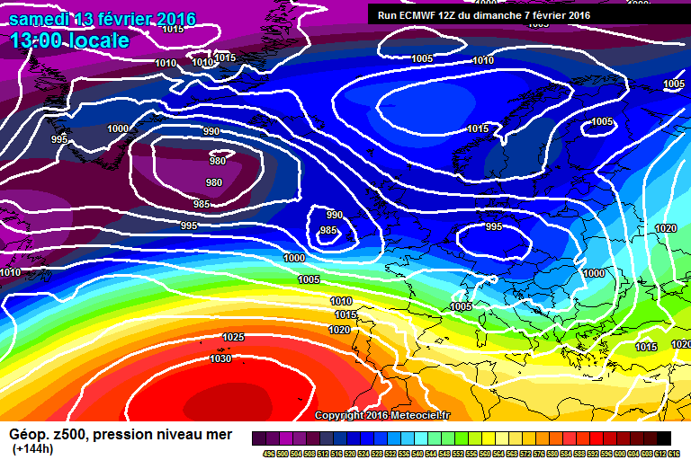
6 minutes ago, Captain Shortwave said:
Well the weak wedge of heights to our north is a positive tonight, the ECM and GFS having a similar idea.
ECM
GFS
Both giving sliders with cold air trying to push west/south west towards the UK.
This is a very delicate scenario though but the fact we are seeing these weak heights being factored in now is a good start. That said the high needs to be between Iceland and Norway, too far west and the trough could simply stall over the UK, too far east and the weak high will get swallowed up by the big Russian high and again we end up cool and wet.
Great set of charts. Over the past few days we have been seeing some of the best potential output since mid January, before that day when all of the models suddenly flipped mild and wet
and since then until very recently the models were once again churning out dismal outputs.
For once this winter I hope things will actually play out in the UK's favour taking into account the rotten luck we have had in getting just about anything in regards to prolonged cold and settled weather and snow.
-
1
-
-
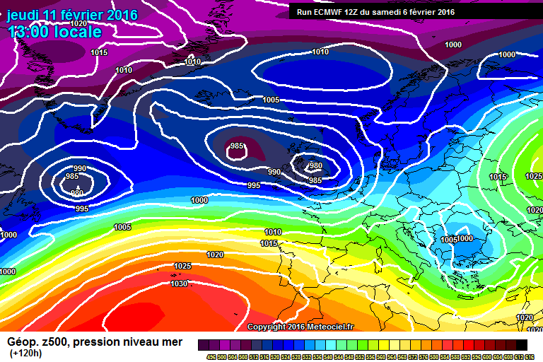
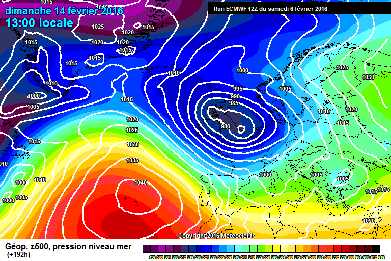
3 minutes ago, Steve Murr said:
All of a sudden a pretty decent winters chart-
not quite deep cold at 144 but cold moving SW towards the UK with another slider waiting in the wings ....
s
Funny how all these interesting model runs and synoptics have been showing up JUST as most of us have been throwing in the towel in regards to Winter
-
2
-
-
13 minutes ago, Timmytour said:
The day to day difference for as little as T96 out is remarkable really.......still a lot ot volatility in the models if the ECM is anything to go by
Tonight v last night v
That looks better right? (An upgrade)
-
6 minutes ago, Banbury said:
Not alot going on the latest forecast, nothing wintry at all
They don't have confidence in models showing cold at present as more support is needed for a colder signal to develop. But this could change. The Met Office usually only support an idea or trend if there is a strong enough signal to do so. We have to watch what happens over the next few days/week.
-
7 minutes ago, Polar Maritime said:
The GFS continues once again with cool/cold 'Wintry' Northerly type flows into the run.
I don't see any 'mild' in those charts!
Will be interesting to see what the Met Office thinks of this, although with possible cold spells such as the one in January they are reluctant to get on board until they have enough confidence to do so.
I also think the impact of Imogen will help to drag colder air down over the UK perhaps causing a change to colder weather again.
-
1
-
-
Hmmm Storm Imogen has got me thinking, as it seems to be a named storm with some serious magnitude, the other coming close being Frank in late December/early January. Remembering how Frank was so powerful and its effects aided the January cold spell (I think), I'm now starting to think what if Imogen will have some sort of impact at aiding cold weather to arrive in the UK again as it looks to be dragging down some cold air as it hits the UK.
The models have been changing so much but the trend of a southerly tracking jet, colder air and possible widespread UK snow has turned up on more than a few runs over the past few days.
-
8 minutes ago, snowray said:
10cm of snow for West London, madness!!
Would definitely be something after the 'winter' so far
-
10 minutes ago, Lampostwatcher said:
Very interesting 18z
I don't know whether this is a stretch or gun jumping from me but the trends over the past few days to me have hinted developments in favour of cold may be tentatively unfolding for the UK. For the sanity of coldies and those of us who want a break from storms I hope this is what's happening & that things don't go wrong and mess up any further chances of cold weather yet again.
-
2
-
-
Well what do we have here? Snow events in the South?
-
2
-
-
8 minutes ago, feb1991blizzard said:
It all depends on the type of warming, if its a wave 2 split type with complete reversal, even if it doesn't have immediate implications, its very likely at some point during the rest of winter / spring we would get potent cold.
Personally I think our next best chance for potent cold is early Spring, tying in with Ian Pennell's thoughts, should the warming be as you described.
-
8 minutes ago, Abyss said:
All I've heard all Winter long is a cold spell is dependable on a SSW in the second half of winter and now apparently it was a hindrance. That's why I don't buy in to long range forecasts no matter what signs etc are showing. As you said yourself the implications the hurricane had and no one could have foreseen that happening therefore LRF are a waste of time IMO. 90% of time we'll have wind and rain in Winter its our climate. Hindsight is a great thing looking back at what made things go wrong but in reality it was only a guess to begin with.
It could have helped had it not been simply a displacement with an unfavourable position for the UK.
-
1
-
-
A great summary from Tamara. The winter so far has been 95% horrible and what most people are looking for now in model trends is dry weather as opposed to snow. Basically we have had the worst possible luck in regards to how this winter has played out in that we are literally clutching at the last possible straw in the MJO to give the UK colder conditions. The UK could have had some colder and more settled weather by now had it not been for Hurricane Alex and the unfavourable strat warming but unfortunately luck wasn't on our side. If the MJO doesn't work out either then I think that's really it and roll on Spring and more so Summer which hopefully can make up for the horrible weather we have had to endure so far as surely 4 months of predominantely rain and gales cannot continue for much longer- that would be a stretch even for the UK imo and people would go absolutely crazy. Hopefully it will balance out in the end
There is always light at the end of the tunnel; recently Summer 2014 after the similarly horrid winter.
-
8
-
-
Wasn't GFS 06z hinting at possible high pressure next week?
It would be nice if the models and forecasters could firm up on an outcome after next week on this and hopefully a true end to the incessant wind and rain of the past 4 months as opposed to a few dry days only. Its really feeling like early 2014 right now where we were looking for absolutely any signs of a dry out after being pelted with storms day in and day out for months on end.
-
1
-
-
3 minutes ago, snowray said:
Mildest Northerly I have ever seen in February, Just about sums up this Winter!
That's a really confusing chart. There seems to be cold air over the UK though?
-
11 minutes ago, Singularity said:
Okay... might take until +192 with the W. Atlantic feature.
Interesting how the individual disturbances within messy trough at +144 again refuse to merge into a single storm system. The southern arm of the jet is just too enticing... so we end up with another angry looking low heading for southern UK. Thanks, ECM *sarcasm alert*.
Edit:I saw it first!
That looks like a lot of blue
-
1
-
-
Although it is comforting to remember that another year with a major El Nino (1983) had a cold spring from March - May and a hot summer following a mostly mild winter.
However in other El Nino years where the Nino was not as strong such as 2007 and 2011 as recent examples, the springs in those years were warm and dry but the following summers were cool, wet and unsettled due to a quicker Nina transition during the late spring and summer as the Ninos for those years declined faster.
I'm not saying its a clear correlation but hopefully this year ends up closer to 1983 in similarity give or take.
Also Ian isn't ruling out some warmer periods during the spring either.
-
1
-
-
15 minutes ago, weirpig said:
In the closer timeframe there is most certainly a trend for the jet to start to dig further south giving parts of the country a chance of seeing some snowfall. But for me espicially in fi i cant help notice the amount of precipitation thats falling right through low res most of us would need a ark if that come to fruition.
I think it could either be snow or freezing rain depending on one's location
-
1
-
-
What's interesting and perhaps different from the past week or two of model watching since the January cold spell ended is that we're now seeing potential cold outputs closer than the usual 'day 10' which never comes off and is usually binned after a day. But the fact that the jet sinking south has been shown on a few previous runs prior to tonight's is giving me a bit more confidence that perhaps the models are on to something developing as opposed to another 'garden path' situation.
-
1
-
-
7 minutes ago, bluearmy said:
There are some interesting developments today for coldies. Many runs continue to play with southerly tracking lows and negatively tilted troughs. this could deliver snowfall if we can advect cold air far enough South. I wonder if the south Welsh hills could be a winter wonderland come next weekend??
Anyway, we'll see if this possible Icelandic heights rise gathers any pace in the morning output.
Yes, interestingly there have been a few runs such as yesterday's which also had a southerly tracking jetstream with lows running south of the UK before being dropped this morning and picked up again in tonights ECM
-
1
-


 and since then until very recently the models were once again churning out dismal outputs.


 There is always light at the end of the tunnel; recently Summer 2014 after the similarly horrid winter.


Model Output Discussions 18z 31/01/2016
in Forecast Model Discussion
Posted · Edited by wishingforsnow
Yes as some runs this evening have shown its not yet a clear cut outcome to cold and that positioning could have a major impact on what we end up with - as at the moment different scenarios are possible. So the Beeb and Met can't call anything until a clear outcome is shown.