


The Eagle
-
Posts
2,080 -
Joined
-
Last visited
Content Type
Forums
Blogs
Gallery
Events
Learn About Weather and Meteorology
Community guides
Posts posted by The Eagle
-
-
The best way I can describe the mid term 6 - 12 days out look is that it's becoming ever more normal really. Wind potential aside neither particularly cold nor mild.
Just run of the mill deep depressions.
-
 1
1
-
-
ECM looks good at 120 just about.
It's VERY close though at 96 hrs. A nudge here or there and it's the UKMO/ICON.
-
1
-
-
The GFS control run is, if anything, even more awesome than the op.
-
3
-
 1
1
-
-
00z GFS is great but overwhelmed really by poor ICON, UKMO, GFS(P)
All down to the ECM. Depending on which way that goes it will be great here later or absolutely appalling.
-
Quite a snow maker on the GFS op though...

-
6
-
1
-
-
GFS looks like it will rescue something. Impressive enough in to GL.
-
1
-
-
GFS may just about rescue it but the UKMO is not good. We don't want that shortwave pumped up like that, ditto the phasing.
-
If the GFS or UKMO are anything like that it's the beginning of the end really for prospects in the latter half of January in my opinion, but we'll see.
-
ICON first out. Not good. Not good at all.
-
Looks like a step toward the ECM here. More progressive off Newfoundland @ 144hrs, heights not as evident over GL
-
1
-
1
-
-
This really is a very disappointing temperature profile return on a regime like this for the first half of January
-
4
-
-
1 minute ago, Skullzrulerz said:
So if the low was further south would it also bring colder air into the UK? Just trying to understand the meaning here
At that point it would be bringing the beast. Something much more potent if we get there.
-
2
-
-
5 minutes ago, nick sussex said:
It’s still redeemable even with the day 7 chart if the block is further north into Greenland but by day 8 the writing is on the wall .
We still have time for changes so I’m not going to get in the emergency staff yet for the NW helpline !
On the contrary it's a fanastic run for the simple fact it isn't far away at all. It's also on it's own with that one aspect. Wouldn't be surprised if it's a synoptic outlier there.
-
1
-
-
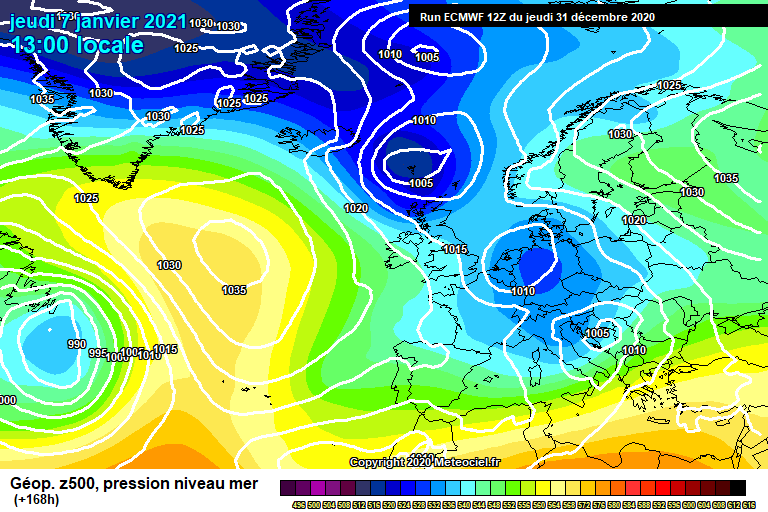
7 minutes ago, nick sussex said:
This mornings ECM run had a much better evolution. Here the shortwave deepens into a bowling ball low . This is always the problem with deep cold hitting the warmer Atlantic .
Luckily we have time for changes and it only starts going pear shaped at day 8.
The problem is day 7. Note the double vortex just off the east coast of GL. We only want one, the southern one...that's the one we need to drop down. Flimsy extensions like this just disrupt the whole play...
http://www.meteociel.fr/modeles/ecmwf/runs/2020123112/ECM1-168.GIF?31-0
-
ECM made a boo boo at 168 hrs, flips by 216
-
Extraordinary increase in ice extent over the last 24 hours. Hopefully it continues.
-
With far less ice means more moisture to pick up generally which might explain increased scope of snow accumulations in recent years.
To be honest the sea ice situation looks very poor at the moment. Even looking ahead we are struggling to see the depth of cold pooling up there to really speed things up.
Not seeing much sub -16c @850 hpa in the right places for the forseeable!
-
2
-
-
All ground to a halt in the Atlantic. No zones of interest and no new development for at least the next 5 days.
-
1
-
-
It can change quickly to be fair. Hoping for that soon.
Just checking the Longyearbyen and Barrow web cams and not much to see yet in either.
Slow start.
-
1
-
-
Even for the time of year this isn't a great profile within the Arctic Circle in terms of quickening sea ice formation, might even stall it a bit...
-
2 hours ago, The Eagle said:
Still raining in Denver but it will turn to snow tonight for anyone who wants an early fix. Already snowing in the Rocky foothills.
Plenty of webcams online
Snow falling there now.
Better webcam
https://www.earthcam.com/usa/colorado/denver/?cam=denver
-
2
-
1
-
-
Lovely snow falling now on the second webcam there.
It's so beautiful *tear*
-
3
-
-
Still raining in Denver but it will turn to snow tonight for anyone who wants an early fix. Already snowing in the Rocky foothills.
Plenty of webcams online
https://www.earthcam.com/usa/colorado/denver/?cam=denver
https://denver.cbslocal.com/cams/
Telluride which is nearly 200 miles southwest but higher elevation @ 2667m
-
1
-
-
Unusually early cold incursion through the mid west states in the US next few days brining ample snowfall to the higher plains and mountains through Montana, Wyoming and Colorado and as far south as northwest Texas. Denver looks the place to be.
-
1
-


Snow & Ice coverage in the Northern Hemisphere Winter 2021/22
in Spring Weather Discussion
Posted
For salt water surface temperatures should be sub circa -1.7c to start the freezing process. Not in bad shape so far this ice season relatively speaking. Hopefully a pick up in formation next few days.