


The Eagle
-
Posts
2,080 -
Joined
-
Last visited
Content Type
Forums
Blogs
Gallery
Events
Learn About Weather and Meteorology
Community guides
Posts posted by The Eagle
-
-
Well, we'll certainly look forward to that!
-
 2
2
-
-
2 minutes ago, AppleUK 123 said:
Forgive my ignorance, but wouldn’t it be a normal area of low pressure by that point so why would the NHC be interested?
Transitioning Tropical Storm, same as Hurricane Ophelia for example. They won't provide updates when fully transitioned.
NHC was providing regular updates right up to landfall.
-
2
-
-
Wouldn't be surprised if Met Eireann and the Met Office were in touch with NHC on potential impacts on Ire/UK respectively soon if not already.
Still a way to go though.
GFS 6z consistent enough with the 00z regarding potential track.
-
Latest (10 am advisory) from NHC. https://www.nhc.noaa.gov/text/refresh/MIATCPAT3+shtml/280844.shtml?

-
Latest (10 am advisory) from NHC. https://www.nhc.noaa.gov/text/refresh/MIATCPAT3+shtml/280844.shtml?
-
1
-
-
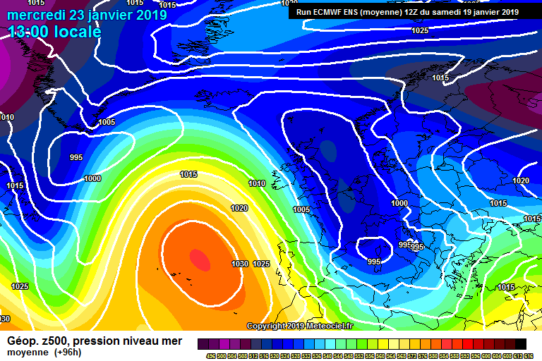
Long way to go but the similarities with Ophelia are striking (even though that path was east of the Azores).
-
1
-
-
-
Yup, still could go many ways. Some fairly notable evolutions out there though
I still favor the track to the west of Ireland keeping it off shore I think.
Should be interesting to track this.
-
1
-
-
Ophelia-esque evolution on the 12z ECM. This could be one to watch.
-
Potentially serious storm for parts of the Azores.
-
Might have minor impacts in western Ireland. Doubt it will reach the UK in any noticable form. It's nothing on the models at that stage.
-
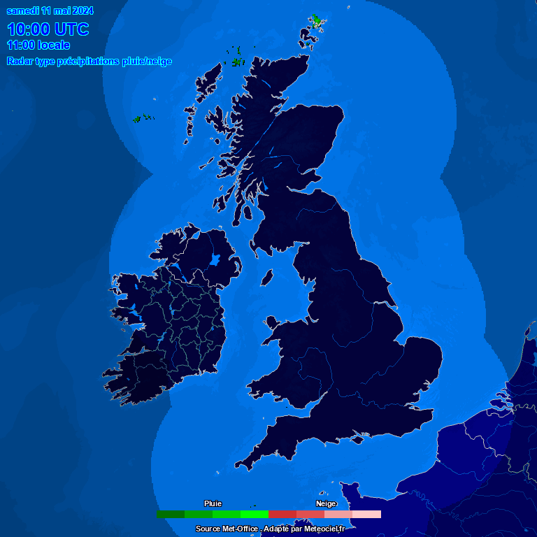
Orange weather warning for thunderstorms just issued for eastern Ireland.
Status Orange - Thunder warning for Leinster, Cavan, Monaghan and Waterford
Thunderstorms will affect the eastern half of the country this morning with heavy downpours, the risk of hail and gusty winds.
Temporary surface flooding is possible for a time, combined with the risk of hail will lead to hazardous driving conditions in some areas.Valid: Saturday 29 June 2019 05:00 to Saturday 29 June 2019 12:00
-
-
Looking intense for Galway tomorrow...
-
-
An entertaining day in the midlands and east of Ireland with widespread snowfall here.
Clearing now.
-
1
-
-
Belting down snow in Dublin now! :D
-
1
-
-
Nice. Temps over 20 to snow in the space of less than a week! (Ireland)
-
2
-
-
2 minutes ago, Jackski4 said:
We live in hope! Let's pray the next set of runs pick up on it...
It doesn't quite make it this time but some significant short term changes there that could make things interesting again.
Down to the other models now.
-
Just now, Jackski4 said:
IS that recent??
That's the 00z, some potentially significant short term changes.
-
Give me hope ICON!
-
3
-
-
Who likes snow?
Looking like a rain to snow event for Monday. I expect a couple of cms before it clears off later in the evening.
-
2
-
-
Frustrating. There is our chance at 96 hrs but would require an unlikely miracle at this stage unfortunately. Just can't get the connection between the mid Atlantic high and Artic high. A tad too much energy through the GIN corridor.
-
2
-
-
While everyone is rightly disappointed with the longer term still snow for many Monday and Tuesday!
Also I think there is still scope for big changes in the next couple of days for the next week or two.
It's not over by any means...
-
8
-
 1
1
-


Hurricane Lorenzo
in Hurricanes, Cyclones and Extreme weather worldwide
Posted · Edited by The Eagle
Always worth remembering the track can change at short notice. Some runs have this potentially impacting southern parts of UK or even through Biscay and in to France.